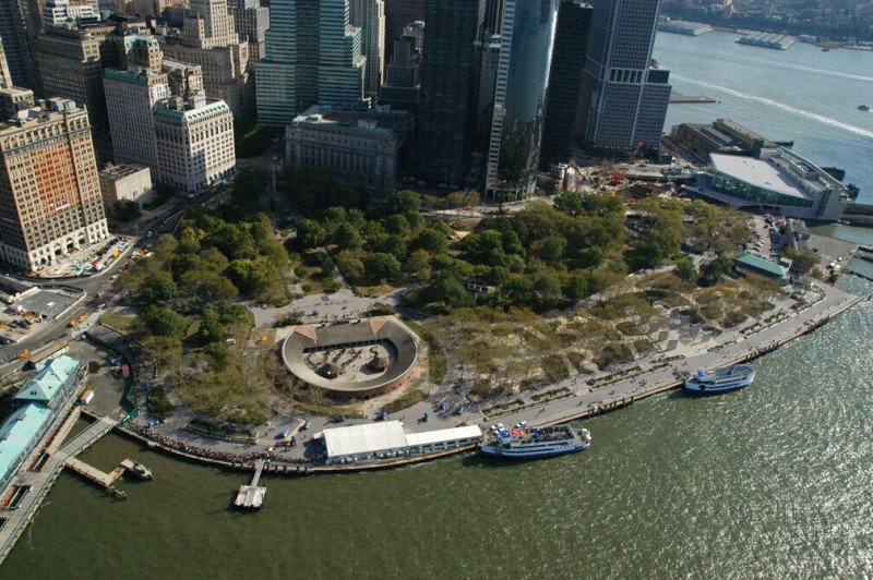
At the southern tip of Manhattan is the first of many historic fortification points along the river, built to protect the Hudson’s communities, resources, and hinterlands from attack. The site of the battery is now Battery Park, the primary place for people in New York City to experience the waterfront. The points of departure for ferries to the Statue of Liberty, Ellis Island, and Staten Island line the shore. On the river side of Battery Park is Pier A, the oldest remaining pier in the city, in 2007 being turned into a visitor center. Like the rest of the shore of Manhattan, Battery Park is an engineered landscape, made on landfill in the nineteenth century, part of the plane between aboveground and underground. Underneath the park’s trees, monuments, and public art, far below sea level, are highways and subway stations, kept dry by continuously operating pumps.
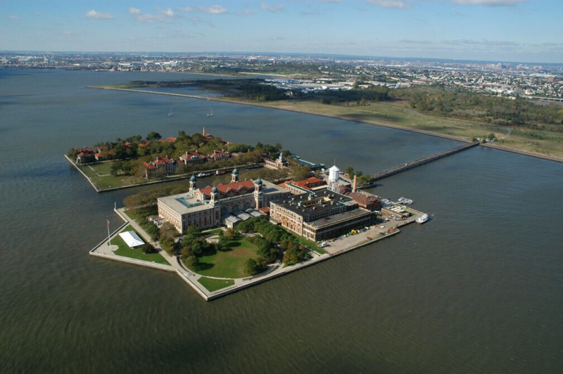
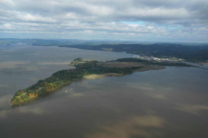
Ellis Island, the famed historic gateway to America, is located at the mouth of the Hudson, linked to Battery Park by ferries and to the New Jersey shore by a service road, closed to the public. There remains some uncertainty about precisely where the island is located. The historic controversy over its ownership between the states of New York and New Jersey was settled in 1834, when the small 3.7-acre island was designated as part of New York. However, since that time the island has grown to more than 27 acres by landfilling (using dredged material mostly from the New Jersey side of the river), prompting New Jersey—to which it is physically much closer—to claim the part of the island not covered in the 1834 agreement. The Supreme Court decided in New Jersey’s favor in 1998. However, the matter remains complicated, as the old island is seamlessly integrated into the man-made portion, and the whole thing is topped by the large, historic structures that are owned by the federal government. Ellis Island, gateway to America through which more than twelve million immigrants passed between 1892 and 1943, and gateway to the Hudson River, is a sort of a hole in the map.
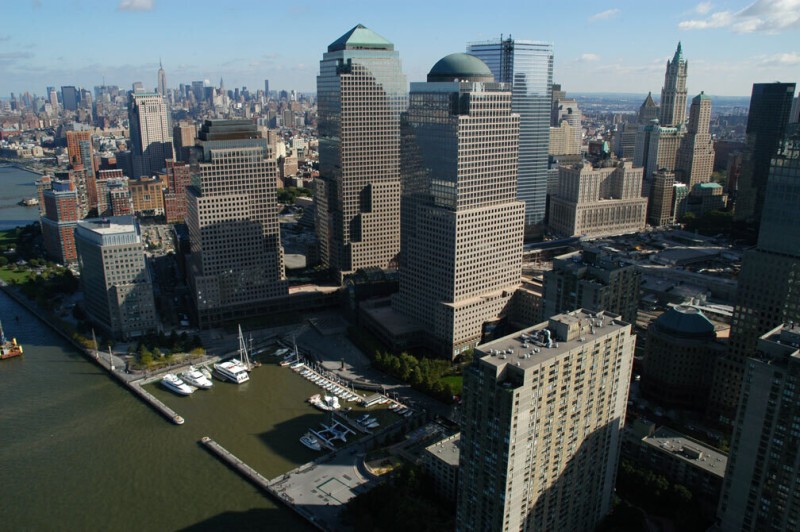
Beyond Battery Park, the Manhattan shoreline curves completely into the channel of the Hudson at Battery Park City. This project is a major landfill development that added another 90 acres of Manhattan where there used to be river. Excavated material from downtown construction projects was used to extend the shoreline to the ends of the obsolete shipping piers, burying many of the piers in the process. Much of this excavated material came from the construction of the World Trade Center in the 1960s and ’70s. The World Financial Center, with the headquarters and offices of American Express, Dow Jones, Merrill Lynch, and Deloitte & Touche, was built in the 1980s and embraces a small yacht harbor called North Cove. Behind the World Financial Center is the excavation site of the now disappeared World Trade Center.
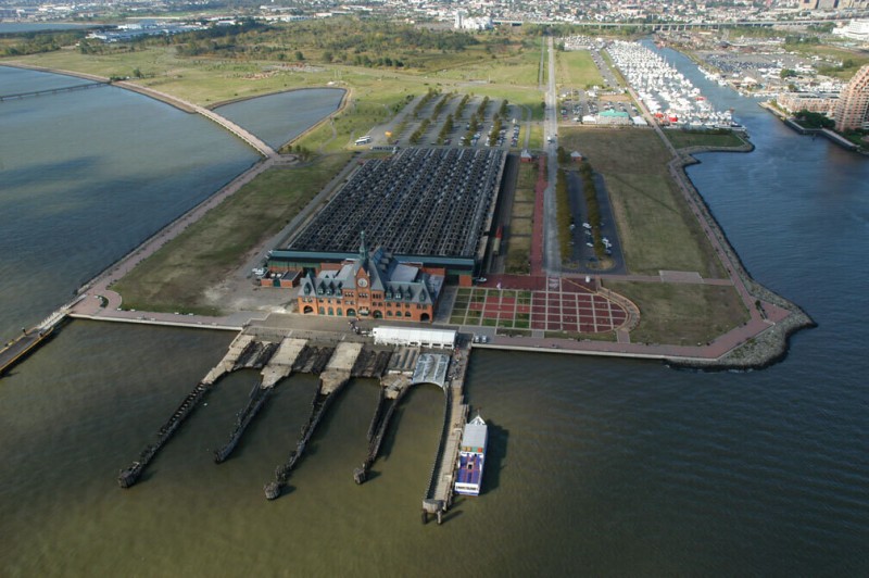
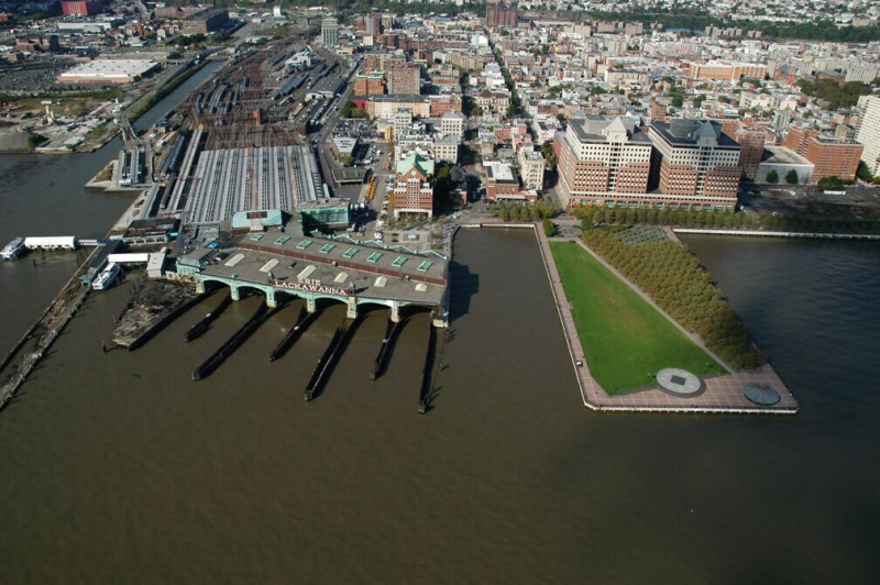
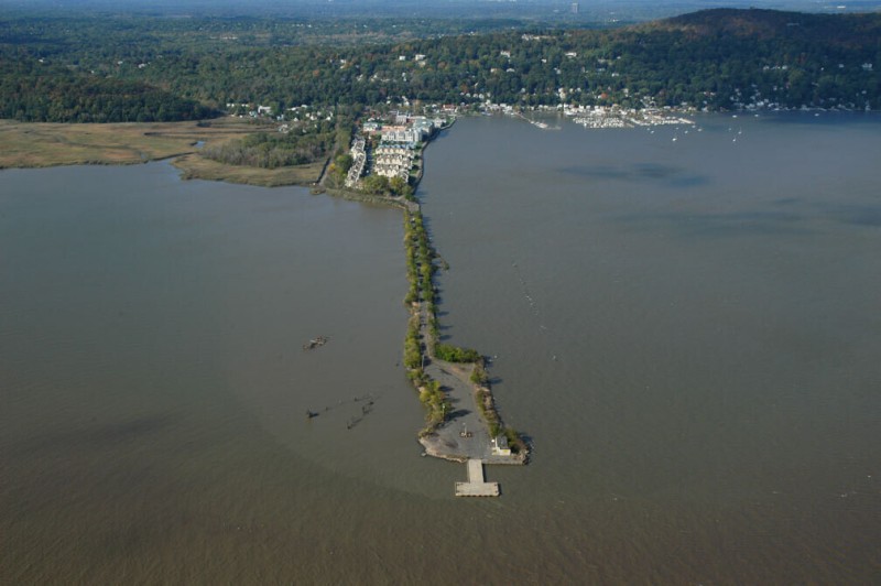
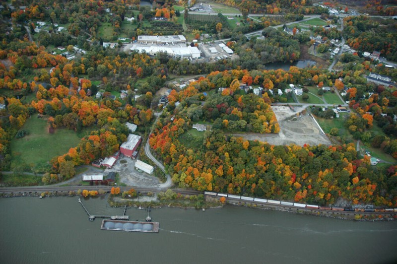
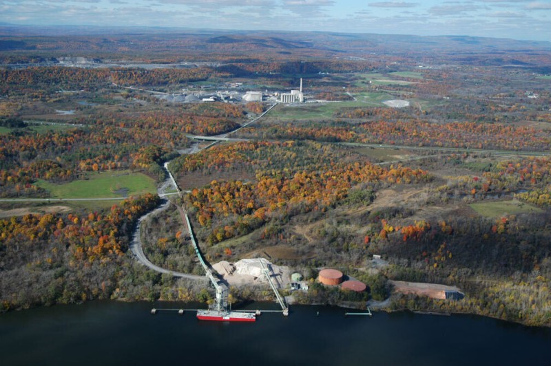
The terminal building for the old New Jersey Central Railroad is a relic, a rail station with no tracks. It sits on the end of a landfilled peninsula that was once a large port and rail yard, the end of the line for the railroad’s link with Manhattan. Passengers would transfer to and from ferries at this point. In 1967 service was discontinued after the PATH (Port Authority Trans-Hudson) took over operation of the Hudson Tubes linking New York City with New Jersey’s Penn Station through rail tunnels bored under the river. After a period of abandonment, the terminal building, built in 1889 in the style of a French château, was renovated and is now used as a visitor center and events hall for Liberty Park. The wide channel on the north side of the park was the eastern end of the Morris Canal, used primarily to transport coal to New York. An artificial waterway that bisected the state of New Jersey, the canal connected the mouth of the Hudson and the Delaware River. This channel is now called Claremont Cove and contains a yacht harbor and luxury apartments.
Among the piers on the Jersey City shoreline that are being redeveloped, remediated, or removed is the pier that covers the plunging Holland Tunnel, with a large ventilator building at its tip. The tunnel opened in 1927 and was the first tunnel in the nation with forced air ventilation. The huge fans in the ventilator building, along with those in an identical structure at the opposite end of the tunnel at Canal Street in Manhattan, can exchange the air in the tunnel in ninety seconds. The 8,500-foot-long tunnel, designed when access to Manhattan was shifting from public transportation to automobiles, opened after seven years of construction. It accommodates thirty-three million vehicle journeys every year. A toll is charged to enter New York through the Holland Tunnel, but not to travel from New York to New Jersey.
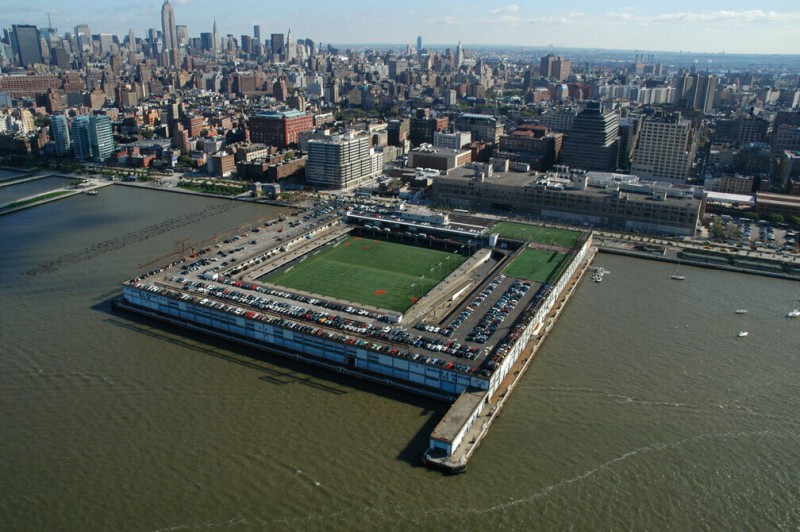
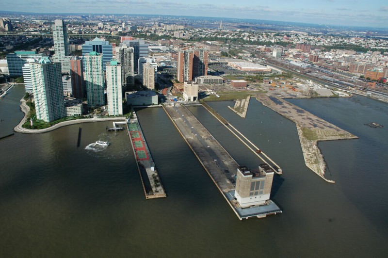
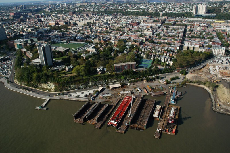
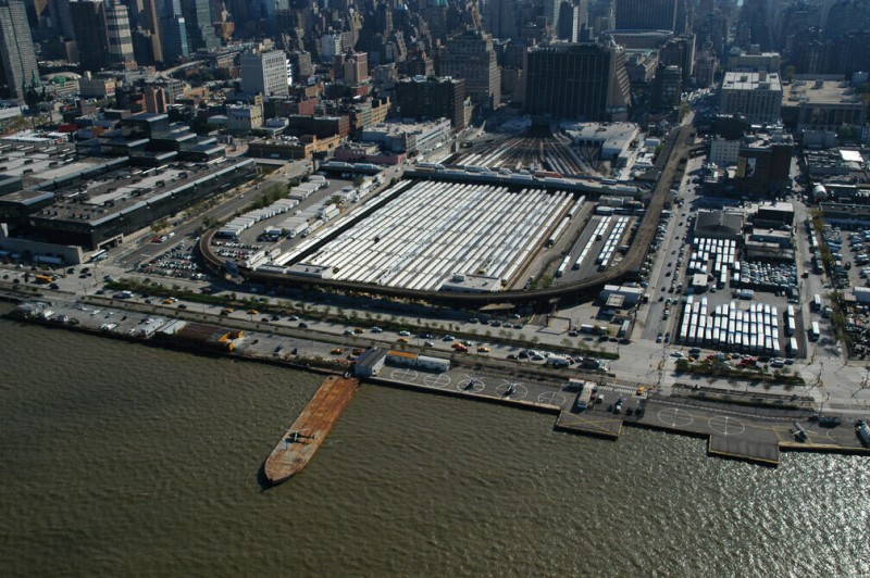
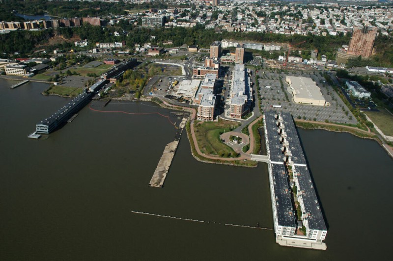
Pier 40, located at the west end of Houston Street, is the only square pier on the shore, and it occupies more than twice the area of the next largest pier in the city. Owned by the Port Authority of New York and New Jersey, its fate is contested, as it, and much of the rest of Manhattan’s Hudson shoreline, is being integrated into Hudson River Park, which will combine as much public and private shoreline space as possible into a multifaceted five-mile-long recreational zone. Comprising 550 acres of open space between Battery Place and 59th Street, this park would be the largest open space development in Manhattan since the creation of Central Park. The park would also be the southernmost part of the planned Hudson River Valley Greenway Trail, which would extend northward up the river all the way to Troy. Whether Pier 40 will be developed as a private complex, like the Chelsea Piers, or as a public park remains to be seen. Meanwhile, the headquarters for the park trust is in Pier 40, with its 2,200 parking spaces and its ball fields.
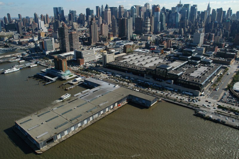
The landmark Beaux Arts–style terminal building in Hoboken was built as the eastern terminus of the Delaware, Lackawanna, and Western Railroad in 1907. It has recently been restored and is still in use as both a rail and a ferry terminal, a rare example of continuous original use of a structure on New Jersey’s lower Hudson shore. North of the building is Pier A, one of the piers of the former Hoboken–Port Authority Terminal, where On the Waterfront was filmed. The pier has been redesigned into a shorefront park.
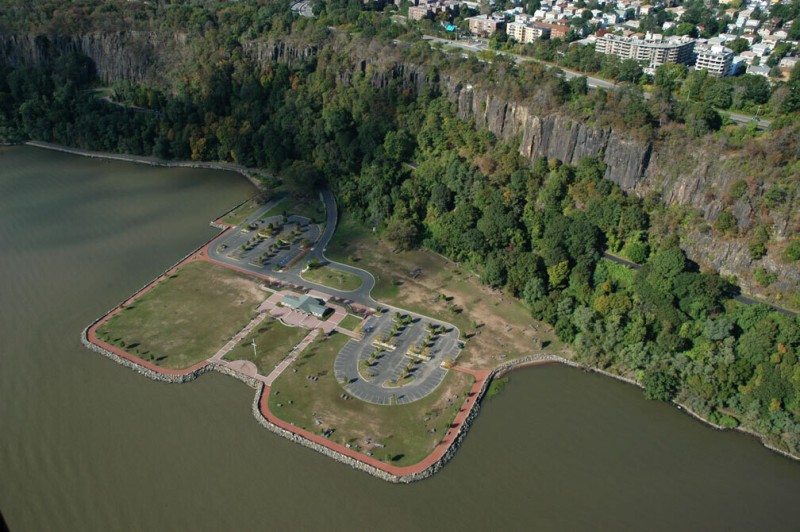
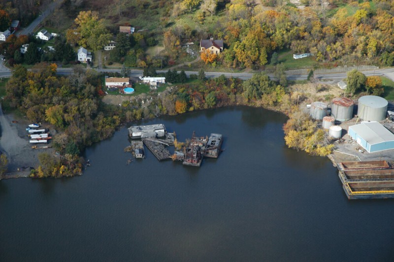
This bit of landfill at Gansevoort Street and 12th Street in lower Manhattan houses a Department of Sanitation facility and Manhattan’s only remaining waterside fire station. The fireboat parked here at Pier 53 is the John D. McKean, which can pump more than twenty times the amount of water of a street-bound fire truck; it was a critical source of water for the fire department after the 9/11 attacks. Pier 54, the flat pier to the north, is the pier where the RMS Lusitania left for its final voyage before being sunk by a German U-boat, an incident that played a key role in the United States’s entry into World War I. On the old rusted metal arch in front of the pier, the name Cunard printed in very faded letters is still visible.
Castle Point, a bulge in the Hoboken shoreline, once had a castle on it (the campus of the Stevens Institute of Technology now occupies most of the top of the hill and the remaining part of the castle). The Union Drydock Company operates one of the last remnants of the working waterfront on the New Jersey side of the Hudson. It services barges at this site, including the gasoline barges that transport fuel upstate from the refineries of New Jersey. An indentation in the cliff under the tower at the Stevens Institute is the location of the entrance of Sybil’s Cave, a popular tourist spot dating to the 1830s. The water in the cave was said to have beneficial properties, although the Health Department eventually closed the cave to the public. The arched portico that was built at the entrance of the cave is gone, and the entry has been blocked by concrete since the 1930s. The Elysian Fields, another Hoboken attraction dating back to the mid-nineteenth century, was located at the north end of Castle Point. It was here that baseball is said to have been invented, when the Knickerbocker Club of Manhattan started playing organized ball in 1846. The fields have disappeared, but a plaque exists at the site on 11th Street in Hoboken.
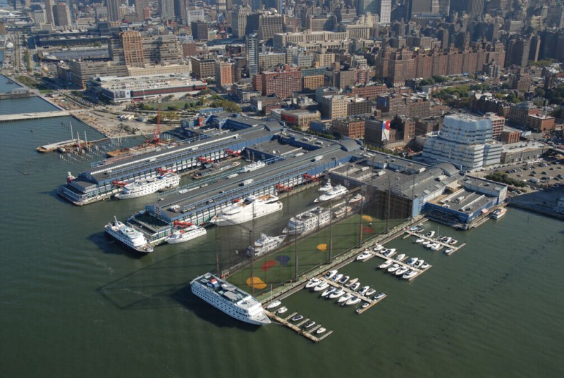
The Chelsea Piers Sports and Entertainment Complex, a privately financed $100 million project involving the commercial development of three historic piers and the long shorefront building that connected them, broke ground in 1994. Piers 59–61 were originally built as passenger liner terminals in 1910, and they served the city as such for a few decades (the Titanic was supposed to arrive on its maiden voyage from Europe at Pier 59). The piers were outmoded by 1934, when the New York Cruise Terminal opened at 47th Street, able to berth the Queen Mary and other large ocean liners. The Chelsea Piers were used for cargo until 1967 and as haphazard city storage and truck repair yards after that. In the 1980s they were slated to be demolished for the Westway Highway, which was never built. Now they house bowling alleys, a golf driving range, ice skating rinks, and other recreation areas, all owned by private companies, and are cited as a model for other private ventures on the shoreline.
North of the Chelsea Piers is the largest contiguous park area in the Hudson River Park, being developed along portions of the west side of Manhattan. When complete, Chelsea Cove Park will provide public access to the waterfront between 22nd and 26th streets. Piers 62 and 64 will be open park piers and the area between them will have grass and trees (the two-story shed that once enclosed Pier 64 was removed in 2006 and will not be reconstructed). Pier 66, at the west end of 26th Street, is already open to the public, with a boathouse, sailboat slips, and public artworks. Next to it is Pier 66A with the recently restored Baltimore and Ohio Railroad float transfer bridge. It is the new home for the Frying Pan lightship and its associated events barge. The barge and the lightship, sometimes accompanied by other nautical relics, represent a vestige of a former and less formal type of space along the waterfront.
Kings Bluff is an escarpment in Weehawken, New Jersey, that marks the beginning of the topographical formation known as the Palisades. On the shoreline is the southern limit of Port Imperial, a massive redevelopment project that is transforming more than two miles of shoreline in an area once dominated by barge and cargo terminals, including the United Fruit Company’s banana depot, which operated until the 1950s. This is also where the Lincoln Tunnel passes under the river; three large ventilator buildings stand in front of the bluff. The Lincoln Tunnel was the second, after the Holland Tunnel, of the two vehicle tunnels built to connect Manhattan with New Jersey and points west. It was built in 1937; a second tube was added in 1945, and a third in 1957. Approximately 120,000 vehicles traverse it daily, making it one of the busiest—as well as longest—vehicle tunnels in the world. A small overlook at the north end of Kings Bluff indicates the site of the famous duel between Aaron Burr and Alexander Hamilton. Here, on July 11, 1804, Hamilton was mortally wounded by Burr, in one of fifteen recognized duels that took place on the dueling ground, situated at the foot of the bluff (now part of the railroad right-of-way).
The West 30th Street Heliport is one of three heliports in Manhattan and is the only one on the west side. It is operated on land and on a pier leased from the city. Beyond it is the rail yard for passenger trains connected to Penn Station, which is located underground to the east. In the 1960s, the aboveground functions of the station were considered an unnecessary use of space, and the Beaux Arts station building, built in 1910, was torn down and Madison Square Garden built in its place. This event was a major catalyst for the preservation movement in New York City and beyond. Today, New York’s Penn Station is the busiest Amtrak station in the country, and some of the ruins of the old station can still be seen near the APA truck yard in North Bergen, New Jersey, in the Meadowlands, where the debris from the demolition was dumped
Pier 76 is one of the largest piers on the Hudson and is familiar to some visitors and residents of Manhattan as the location of the New York Police Department’s car impound and tow lot. Behind it is the Jacob Javits Convention Center, New York City’s main convention center, with an upper level that, at 500,000 square feet, is one of the largest rooms in America. The $375 million center was designed by I. M. Pei and opened in 1986. North of Pier 76 is one of the ventilator shafts for the Lincoln Tunnel. Between the pier and the ventilator is a small outfall that is the remnant of Minetta Brook, a stream that long ago ran through Manhattan.

When complete, the terminal building at Port Imperial may be the largest privately owned ferry terminal in the world, expected to serve as many as five million passengers a year. It is the centerpiece of one of the largest urban master-planned redevelopment projects in the nation. The Port Imperial development is two miles long, equivalent to the distance in Manhattan between 34th Street and 95th Street—sixty-one blocks (though it is a narrow site, hemmed in by the steep bluff). The project involves more than seven thousand housing units in several developments—the Brownstones, Riverbend, Hudson Club et al.—each with different amenities, as well as several shopping centers. The principal developer, Roseland Property Company, may complete the project in five to ten years at an estimated cost of more than $1.7 billion.
Piers 97, 98, and 99 are among the few remaining working piers on the Manhattan side of the Hudson. Pier 99, with a large light blue shed, is the New York City Sanitation Department’s Marine Transfer Station, and it is used to sort trash and load it onto barges for disposal elsewhere (presently most of New York’s garbage goes to Pennsylvania). South of that, Pier 98 is used by the utility company Con Edison as a fuel delivery pier. Pier 97 is currently used by the Sanitation Department as a logistics and parking area. Eventually it may become part of the adjacent Clinton Cove Park to the south.
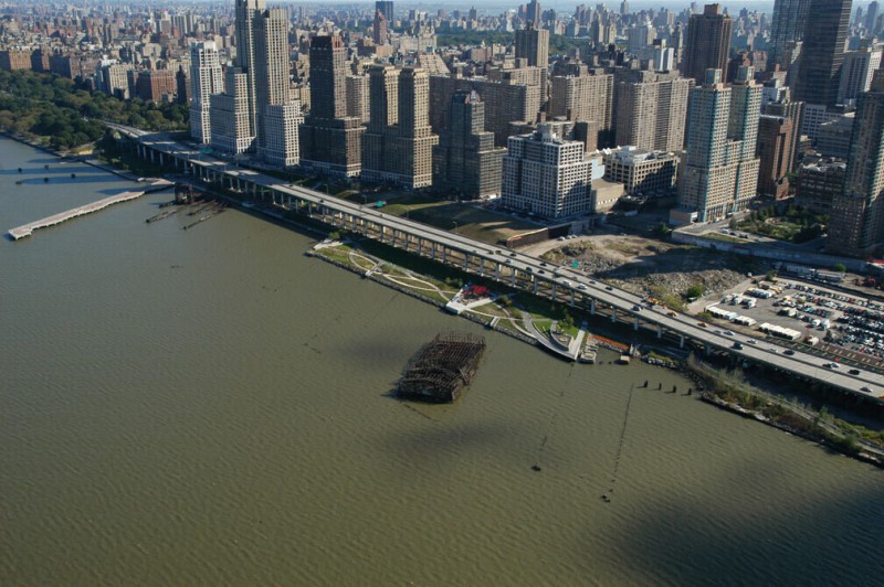
On the shore in front of the part of the 60th Street Railway Yard yet to be developed and the looming Trump towers that have already been built are the ruins of where the rails met the water. For about a hundred years trains were loaded onto ferries and floated across the river between New York and New Jersey. This system called for piers to be set diagonal to the shoreline, requiring less space for turning track on shore. The ruins of these piers, designated alphabetically from A to I, instead of numerically, have nearly entirely been removed, though a few collapsed structures have been spared and will remain as monuments, integrated into the shoreline as romantic scenery at the promenades being built as part of Trump City. At the southern end is Pier D, a rusted steel-framed lighterage pier, one not connected to the shore (and therefore harder to approach). Its neighbor Pier B, removed in 2003, was connected to the shore. At the northern end of the rail ferry yard is a set of three car float bridges, each of a different type, used to move the train cars onto the ferries. At the end, Pier I, with a wavy edge, has been turned into a park pier.
This part of the shoreline of Edgewater, New Jersey, where several chemical plants and other industrial operations have left their legacy in the soil, has been redeveloped into condominiums and shopping areas. At the southern edge of the site is a recently vacated plant belonging to the Dutch cosmetics and food multinational Unilever; north of that is the Edgewater Test Center, where the company conducts research to expand its extensive consumer product line, which includes Wishbone salad dressing, Vaseline, Breyers ice cream, and Slimfast. This occupies part of the former Spencer Kellogg plant site, where oils for paints and wood preservatives were manufactured, and a portion of which is now the Palisades Child Care Center. Next to that is the Quanta Resources Superfund site, an as yet to be redeveloped former coal tar distillation plant, which became a waste oil recycling site, closed by the state’s environmental department in 1981 after the discovery of PCB contamination. The northern portion of the Quanta site has been developed into the City Place shopping/living area, a 162-unit luxury apartment complex on an 800-foot pier extending into the Hudson, which was formerly part of the Celotex Industrial Park, where various chemicals, coal tars, and asbestos products were manufactured. At the north end, where the Lustrelon spray paint and solvent facility once was, are a sixteen-theater multiplex cinema and the Sunrise Assisted Living senior center.
The Ford Motor Company operated an assembly plant on this site in Edgewater, New Jersey, from 1930 to 1955. Designed by the legendary industrial architect Albert Kahn, the plant was a grand ruin for decades, until it was demolished in the 1990s. Now a large parking lot and housing development occupy the site, along with the Edgewater Commons shopping center. Part of the cement slab of the main assembly plant was used as the foundation of the Independence Harbor condominium complex; on the north side is a Target store and a putting green. Across the road is the hulk of the vacated Octagon Process, Inc., plant, which for decades produced specialty chemicals for the military; the company still operates in Edison, New Jersey, and is a major supplier of aircraft deicing chemicals.
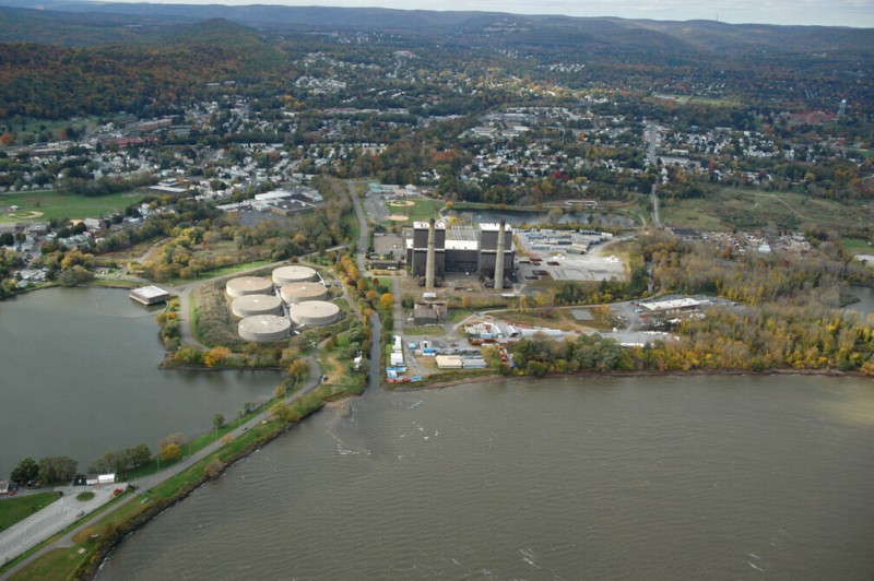
The North River Pollution Control Plant processes sewage generated by the inhabitants of the west side of Manhattan, from Greenwich Village to the northern tip of the island. Before it went online, in 1986, sewage for the west side flowed untreated into the Hudson. The plant—an engineered landscape machine that is part pier, part island, part park, and part building—is the largest modern lateral extension of Manhattan. Extending from 137th Street to 145th Street, the site was selected in 1962 (farther upriver from more central locations on the west side). The $1.1 billion facility took decades to build. The 28-acre platform with 2,300 posts extending hundreds of feet to the bedrock was completed in 1978. The secondary treatment plant was finished in 1991, and Riverbank State Park, on the roof, with a skating rink, three swimming pools, amphitheater, restaurants, and sports fields, opened in 1993. An 11-mile-long interceptor pipe under the shoreline of the west side brings around 165 million gallons of sewage to the plant every day, and more than double that when it rains. This is just over 10 percent of the total of the city’s sewage. The rest is handled by thirteen other plants located throughout the five boroughs.
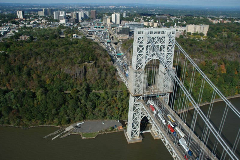
The George Washington Bridge, one of the largest and most dramatic bridges in the world, opened in 1931. It is also one of the busiest, carrying nearly three hundred thousand vehicles a day (comparable to the West Coast’s San Francisco Bay Bridge, 2,895 miles west at the other end of the highway). Just south of the bridge’s western landing is Fort Lee, New Jersey, with ruins of Revolutionary War batteries, which failed to protect the Hudson from the British. Below Fort Lee, on the water, is a landing known as Hazards Dock, which, like Dupont Dock just south of it, was used as a transfer point for the explosives used to blast rock in the quarries of the Palisades. It is now a public boat launch despite the bridge’s classification as a major terrorist target, requiring all boats to stay at least 30 yards away. This portion of the roughly 20-mile-long rock face known as the Palisades was used as a motion picture production location for many years in the early 1900s. Films shot here include The Perils of Pauline, a popular series of films that debuted in 1914, whose dramatic episodes came to be known as cliffhangers because the narrative often involved the steep topography.
Ross Dock is a slab of artificial ground built out of sunken barges and landfill that extends into the Hudson from the base of the Palisades. After the end of quarrying in this region, Ross Dock was one of a few favored camping spots along the river for New Yorkers, though in this case camping was at a fenced, private campground that accommodated more than three thousand people and had running water, hot showers, and toilets. The use of the beaches along the base of the Palisades as swimming and camping sites declined in the 1930s with the closing of the many ferries that crossed the river, following the construction of the George Washington Bridge. Ross Dock has been reopened as a picnic grounds by the Palisades Interstate Park.
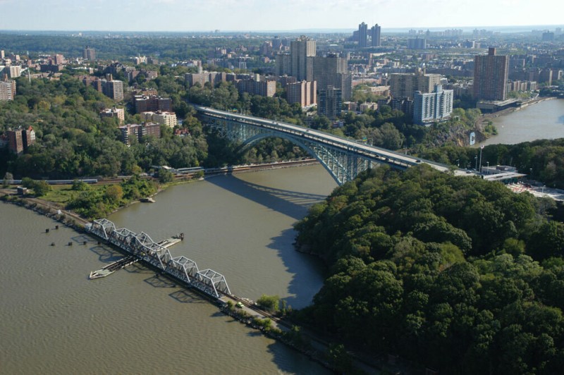
By the time the shoreline of the Hudson reaches the northern tip of Manhattan Island it is an engineered roadbed for the railway, continuing upriver for more than a hundred miles with only a few short interruptions. At the island’s tip, the solid-fill roadbed is perforated for a few hundred feet to allow the Harlem River to meet the Hudson, under a bridge that swings open should a large ship need to pass (which it rarely does). The swing bridge and this part of the rail line were built a hundred years ago but abandoned in the late 1960s. The section was put back in service in 1991 when the West Side rail line was linked to Penn Station. Manhattan’s northern tip is also connected to the Bronx and Yonkers by the Henry Hudson Bridge, which links the Saw Mill River Parkway to the Henry Hudson Parkway, cut through the relative wilderness of Inwood Hill Park by New York’s master engineer, Robert Moses, in 1936.
Alpine Boat Basin is an artificial landing and marina managed by the Palisades Interstate Park. It was formerly accessed from Yonkers by a ferry, a service discontinued in 1957 after the opening of the Tappan Zee Bridge. Alpine once consisted of a cluster of houses and businesses in the narrow line of habitable ground under the steep face of the Palisades, collectively known as Undercliff. The people of Undercliff were woodcutters, farmers, quarriers, and, mostly, fishermen, dating back to the early Dutch settlers. Most of the buildings from the Undercliff period are long gone or are foundation holes in the overgrowth. What remained in 1900 was torn down by the newly formed Palisades Interstate Parks Commission. Alpine used to have more than a dozen buildings, of which one remains, Kearney House, a colonial tavern painted bright white, restored by the park. Part of this building dates from the 1760s; it was used as a police station by the park until the 1920s and was therefore spared demolition. The current police station and park headquarters is at the top of the cliff, just north of the Alpine dock.
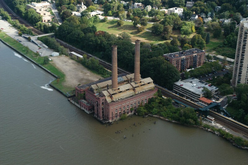
The Yonkers Power Station is a monument of industrial decay on the Hudson, the largest remaining wild, abandoned hulk left on the river. It was built in 1907 to power the newly electrified line of the New York Central and Hudson River Railroad. Shut down in 1963, it has remained unused. The machinery inside the generating station was sold for scrap, and now the empty turbine hall resembles a cathedral nave. It is privately owned and its fate is pending, though it is likely to be preserved in some form and turned into a part of the shoreline redevelopment of Yonkers. Above it, on the other side of a pedestrian bridge over the tracks, is the Hudson River Museum, dedicated to the river and the region. Exhibits include landscape paintings of the Hudson River School and a three-dimensional map called the Hudson Riverama.
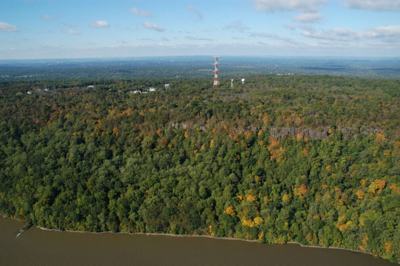
A massive communication tower atop the Palisades looms above the river. This is the Armstrong Radio Tower, a 485-foot-tall antenna, built in 1938 by the radio pioneer Major Edwin Armstrong. Armstrong is generally considered to be the inventor of FM radio, and this tower is the first major FM radio tower in the world. In the 1930s Armstrong failed to persuade RCA and NBC, which dominated the commercial airways of America, of the advantages of his Frequency Modulation technique, which he had been testing using the Empire State Building as a transmitting base. Going it alone, he cashed in his RCA stock and used the money to build this tower at Alpine, across from his home in Yonkers, from which he could bathe New York (and the RCA headquarters) in clear-sounding FM radio. The tower is now used by nearly every major communications company in the greater New York City area, including TV stations, PCS, cellular, two-way radio, and police and fire units. Use expanded quickly after 9/11, when communications in Manhattan were crippled. Its three horizontal arms, a configuration unique in the industry, can support a great many antennas. It is now owned by the CSC communications company.
The former Anaconda Wire and Cable plant at Hastings-on-Hudson is a 28-acre Superfund site undergoing remediation until around 2010. Most of the old industrial buildings on site have been or will be removed to excavate the contaminated soil underneath them. These contaminants include PCBs and heavy metals and, other than soil removal (up to 12 feet down), efforts to keep them from migrating off site include adding sheet pilings along the shore, dredging and capping the site, and raising the grade of the site by 5 feet with the addition of clean fill. The Anaconda plant opened in 1891 and employed 3,200 people at its peak, making cable for electrical distribution, aerial tramways in Europe, and, later, telephone and television cable. It operated until 1976 and was acquired by the Atlantic Richfield Company (ARCO) when the company bought the assets of the Anaconda Company, which included the Berkeley Copper Pit in Butte, Montana, a source of the wire plant’s copper. The drainage area for the Berkeley pit is often called the largest Superfund site in the nation. The PCB contamination of the sediments of the Hudson, due mostly to General Electric’s plant discharge in Glens Falls, north of Troy, is also referred to as the largest Superfund site in the nation.
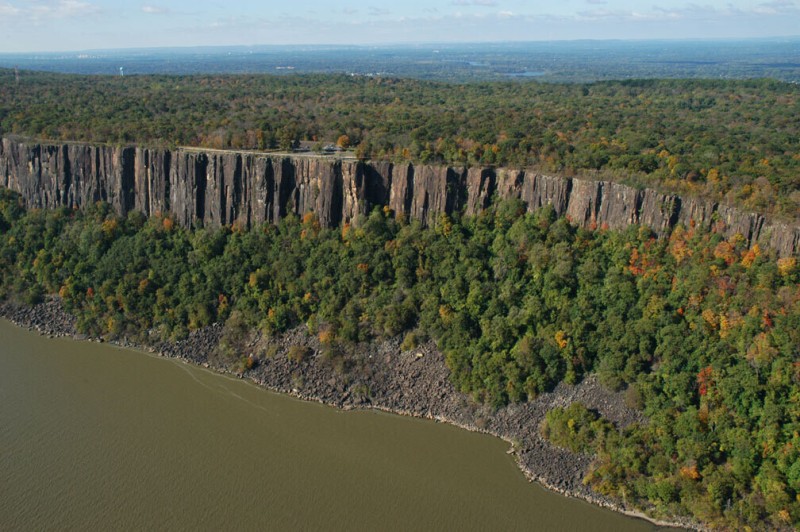
The State Line Lookout is the northernmost lookout on the New Jersey portion of Palisades Interstate Park. The cliffs here are dramatic, their columnar palisaded rock formations most clear, and the talus (the coarse rubble at the base of the cliffs) is near to its natural state. Downstream, closer to the city, much of the talus was removed by quarriers, who then began blasting the rock face. The transformation of the scenic cliffs into quarries was an affront to the view of many wealthy people who had homes on the east side of the Hudson. Chief among them was John D. Rockefeller, whose country house faced the Palisades. He began to organize other landowners and politicians to stop the quarrying, often by buying the land himself. Eventually, the Palisades Interstate Parks Commission, a public agency, was formed in 1900 to acquire and manage the land on the western shore of the Hudson. Just north of the State Line Lookout is Indian Head, the highest point on the Palisades, at some 530 feet. Just north of that, a half mile from the lookout, is Station Rock, where the state line between New York and New Jersey is marked. This is the northeast corner of the state of New Jersey. North of here, the Hudson lies entirely in New York.
Near the community of Palisades, an exclusive, affluent enclave of older homes, a clearing through the trees marks the path of the Tennessee gas pipeline where it reaches the edge of the river, then plunges below the riverbed to cross the Hudson. This natural gas line is part of a 14,000-mile national system that brings natural gas from the oil fields of Texas and the Gulf of Mexico to markets in the northeastern states. It is owned by the El Paso Corporation, one of the largest pipeline companies in the country. The 24-inch pipe is one of four major gas pipelines crossing the lower Hudson.
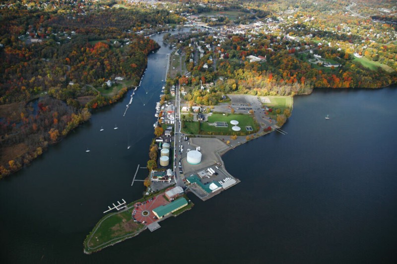
The village of Piermont gets half of its name from the Erie Pier, which extends for a mile from the shore into the river. The pier was built in 1841 as a railway and steamboat terminal by the Erie Railroad, which headed westward from this point, making the town a strategic location for a brief period. The rail yards closed long ago and the town has evolved into a quaint bedroom community. The pier, developed with town houses and a park, continues to cause major siltation in the Hudson River. Above the town is a mountain, providing the other half of Piermont’s name, called Mount Nebo. Mount Nebo had an operational Nike missile battery from 1955 to 1974, one of more than a dozen Nike missile launch sites that protected the New York metropolitan area from aerial attack. The site remains, but the missiles are gone.
The giant concrete slab that used to be the site of the General Motors factory at North Tarrytown is just beginning to be redeveloped. In 1900 a factory on this site made steam-powered cars. In 1914 GM bought the plant and expanded it into one of the company’s longest-operating factories. GM made Chevrolets, Pontiacs, and Oldsmobiles in one of the largest and most conspicuous industrial sites on the river. The plant closed in 1996 and was torn down in 1998. GM, which still owns the site, has hired the Roseland Property Company, which is doing much of the Port Imperial redevelopment on the New Jersey side of the Hudson, and the current plan, named Lighthouse Landing for a restored lighthouse visible on the edge of the property, calls for more than fifteen hundred residential units, office space, parking, and more than 180,000 square feet of retail businesses. Reflecting these changes, from factory town to bedroom community, North Tarrytown officially changed its name to Sleepy Hollow in 1997.
Rockland Lake is a spring-fed natural lake that sits some 150 feet above the Hudson, behind Hook Mountain. The lake is the headwaters for the Hackensack River (which ultimately becomes the principal drain for the hyperindustrialized, landfilled Meadowlands of New Jersey). Before the days of artificial refrigeration, Rockland Lake was a major source of natural ice for New York City, the Hudson River’s water from this area being too brackish to be made into ice. The surface of the lake would be cut into large cakes that were transported down the side of the mountain on an inclined railway to ice storage houses at the base of Hook Mountain. The last ice harvest here was in 1924. When quarrying began to scar the hillsides, Hook Mountain and Rockland Lake were bought by preservationists and became part of the Palisades Interstate Park system. The town of Rockland Lake, which once housed ice and quarry workers, is virtually abandoned inside the park. The water quality of the lake has degraded significantly, due mostly to the urban runoff from surrounding development. To compensate, the state has built two large swimming pools on opposite ends of the lake and massive parking lots for more than three thousand cars.
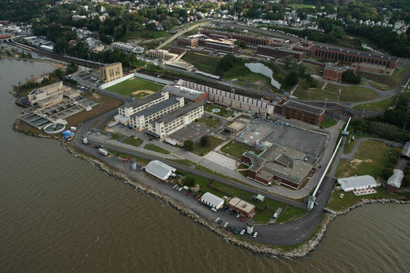
Sing Sing Prison in Ossining is one of several prisons in the Hudson Valley but the only one directly on the shore. Its location north of New York City is a probable source of the negative connotation of being sent up the river. Construction began on the notorious prison in 1825 and it opened in 1828. Today it houses around twenty-five hundred inmates, most of whom are in maximum security. About a fifth of the inmate population has been convicted of murder. Sing Sing was also the site of the state’s electric chair, where 614 people, including the Rosenbergs, were killed in the Death House, a space now used for vocational training.
Tellers Point is the tip of Croton Point, a large landmass that projects into the river, marking the transition from the Tappan Zee to Haverstraw Bay. At nearly three miles across, it is the widest part of the river. Though Croton Point became a county park in 1924, it was the primary landfill for Westchester County for many years after that. By the 1970s the federal government intervened to close the dump, which was said to be leaking forty million gallons of leachate into the river annually. In 1995 the final capping of the dump, visible as a clearing in the middle of the peninsula, was completed. A rail yard at the base of the point is at the Croton-Harmon Station, on the Metro North railroad’s Hudson Line, which runs 74 miles between Grand Central and Poughkeepsie. These yards were an important point on the commuter rail line, for until 1968 this was the northern limit of the electric-powered trains. It still serves as a major maintenance yard for the MTA. Also at the base of Croton Point is the Croton River, which, a few miles inland, was impounded by the New Croton Dam in 1905 to enlarge the reservoir that serves as the terminus of the Croton water supply system, one of New York City’s three water suppliers. The New Croton Aqueduct runs south from this reservoir 33 miles, bringing three hundred million gallons of water per day to New York City.
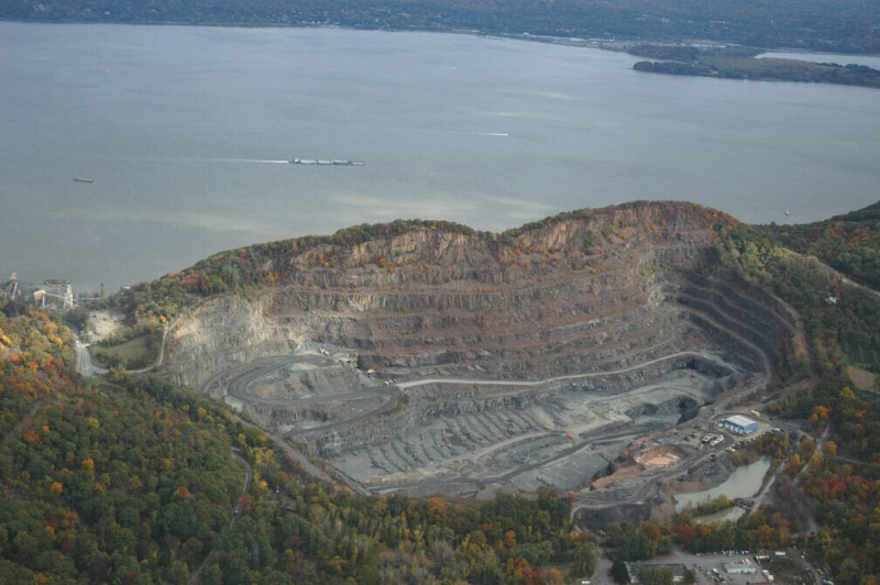
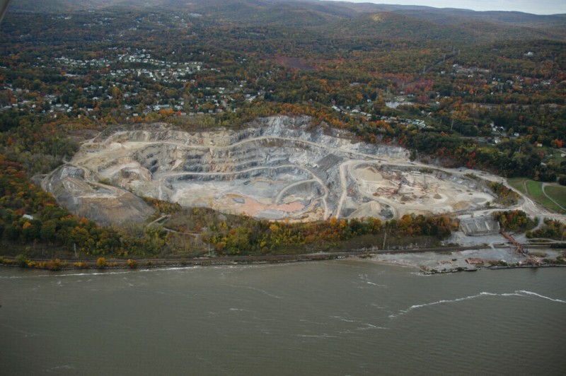
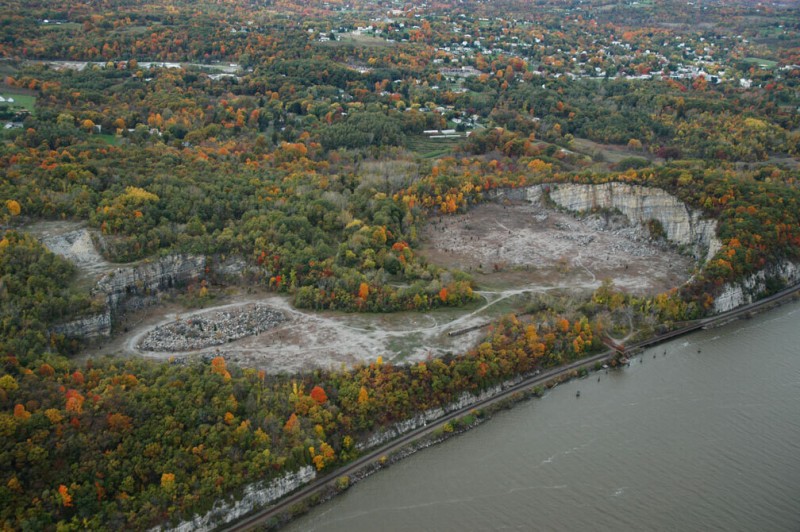
The Haverstraw limestone quarry was part of the extensive holdings of the New York Trap Rock Corporation, which had acquired most of the major quarrying sites along the lower Hudson by 1920 and operated them until the 1960s. At that point the quarry was sold to Martin Marietta. Known as a defense contractor, Martin Marietta, like General Dynamics, diversified into the construction materials business for a while. Tilcon NY, one of the companies of the Irish aggregate multinational CRH, now owns it and many other quarries in the lower Hudson, including North Kingston, Clinton Point/Poughkeepsie, and Tomkins Cove, as well as many inactive former New York Trap Rock sites. Haverstraw Quarry is invisible from the eastern shore of the river, where most of the industrialists’ mansions were located and romantic landscape painters had their homes. The contour of the ridge has been preserved.
High Tor is a famous landmark on the river and the subject of more than one Hudson River School painting. At the base of High Tor is Tilcon’s loading dock and aggregate yard for the region’s quarries. Here rock is ground to different sizes for different applications and is shipped by barge to other terminals or by truck to construction sites; it also is connected to the Haverstraw Quarry by a conveyor. In the 1930s New York Trap Rock started major quarrying operations on High Tor itself. The Rockefeller-fueled Palisades Interstate Parks Commission, which had stopped many of the quarries along the Palisades by buying the property for parkland, eventually forced New York Trap Rock off of High Tor through eminent domain.
Haverstraw was the capital of the brick industry on the Hudson, and one brick plant remains, inoperative and in partial collapse, on a peninsula near downtown. Material was mined from quarries in the region and from deep clay beds just offshore. At the peak of the industry, in the 1880s, there were forty brick plants in the Haverstraw area alone, producing more than three hundred million bricks per year, and dozens more plants up the Hudson. The plants took advantage of the river as an easy route to transport the bulk material to markets along the shore, including, of course, New York City. The shoreline around Haverstraw is greatly transformed by these decades of mining. In the early 1900s the bulk of brick making moved south as the industry was supplanted by the increasing use of concrete, also produced in great quantity on the Hudson for similar reasons of the benefits of the physical environment.
The Bowline power plant is one of the largest power plants on the river, generating 1,125 megawatts of energy. It was built in 1974 and burns natural gas and oil. In 1999 it was sold by its longtime owners, Orange and Rockland Utilities and Con Edison, to Mirant, an Atlanta-based electrical utility, with about twenty-five power plants nationwide. Mirant (formerly called Southern Energy) suffered when the wholesale energy industry collapsed with the implosion of Enron and filed for bankruptcy in 2003, the twelfth-largest corporate filing in U.S. history at the time, though it continued to operate its plants. In 2006 the company emerged from Chapter 11, except in New York, where it operates two Hudson River plants, Bowline and Lovett. The county and local communities have been severely affected by the loss of tax revenue from the plants.
The shoreline around Haverstraw is a pockmarked network of peninsulas, islands, and ponds left over from the digging of clay pits by the brick industry a hundred years ago. A U.S. Gypsum plant is located on one such incidentally engineered landmass at Grassy Point. U.S. Gypsum invented a product it called Sheetrock in 1917, and it is now the largest wallboard producer in the world. This is one of twenty-one gypsum board plants operated by the company in the United States. The company also operates eighteen joint compound plants in North America (thirteen of them in the United States), fourteen gypsum mines, and a fleet of ships (registered in Bermuda) to move bulk materials around the globe. Most of the raw material for the Grassy Point plant comes by ship from the company’s mine in Nova Scotia, Canada.
Between Stony Point and the Lovett Power Plant is Tomkins Cove Quarry, a dolomitic limestone pit operated by Tilcon. Dolomitic limestone is used primarily to make cement for concrete, and this quarry, which has been worked since the mid-1800s, was the source of the macadam for New York City’s Central Park. Thomas Edison, a proponent of concrete technologies, designed some of the original crushing equipment for this quarry. Edison also designed a system for making houses by pouring concrete into a house-sized mold, and he built a few of these houses in New Jersey. The original owner of the quarry, Calvin Tomkins, made a poured-concrete Gothic house for himself nearby. Pumps operate continuously, as the pit is mostly below the level of the river.
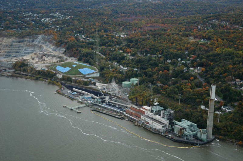
The Lovett Power Plant is one of a dwindling number of power plants on the Hudson that uses coal. Built in the 1950s, Lovett has been modified to burn natural gas and oil too, but it teeters on the edge of economic viability due to pollution and emissions regulations. Without a major investment in modernization, the plant will probably be closed in coming years. A net surrounds the plant, suspended by an inflated yellow tube—called a Gunderboom—that keeps fish from being sucked into the plant’s cooling system.
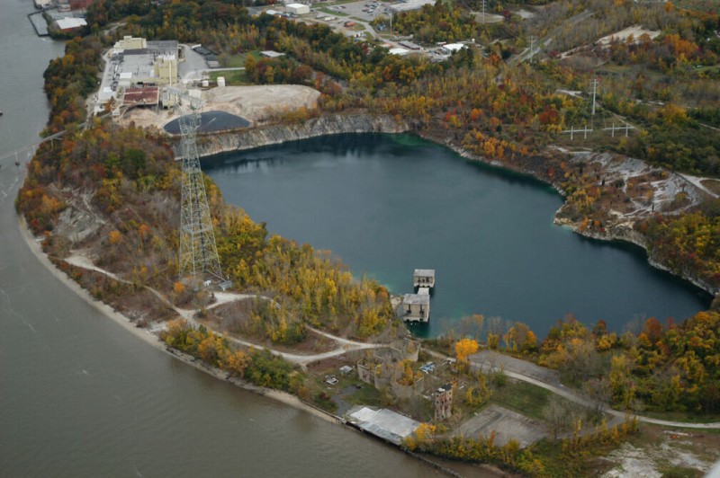
The former Verplanck Quarry next to the river has filled with water and is now a deep, clear blue lake with cliffs and submerged buildings. The quarry operated from around 1900 to 1985, extracting rock and gravel for roadways and construction. It closed when its owner, a retired schoolteacher, moved to Florida and sold the property. Attempts to reactivate the quarry have been blocked by the town, and the site remains in limbo. The state has proposed opening a swimming beach on the site, with access to the river and the lake. However, proximity to the Indian Point nuclear power station makes some people nervous about increasing public access to the currently locked and gated quarry site. Between the quarry and the plant is a large gypsum plant owned by Lafarge. The gypsum is delivered in rock form by ship and is crushed, mixed, heated, dried, and extruded into wallboard at the plant. This is one of four such plants owned by the company and is a major source of drywall for the region.
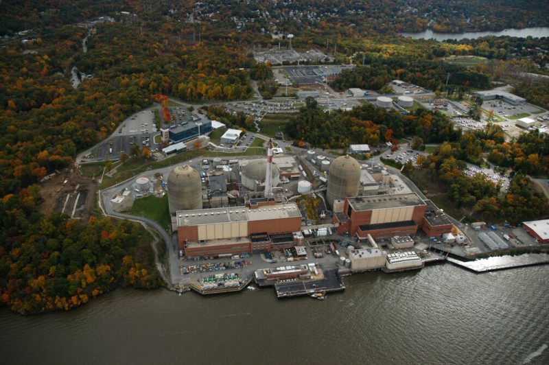
Indian Point is a notorious nuclear power station on the river. It opened in 1962 and added two more reactors, in 1974 and 1976. Built by Con Edison, it is now operated by Entergy, a southern electrical utility that owns eight other nuclear power plants. The plant has become one of the most fortified industrial sites in the nation, in response to concerns about vulnerability to terrorism. Much of the debate about the effects of an airplane flying into a reactor dome are based on this facility, partly because the plant is on the edge of the most populated urban area in the country and because the 9/11 terrorists flew directly over the plant on their way to the World Trade Center. The plant produces 2,000 megawatts, the largest single source of electricity in the New York City region, constituting about 25 percent of the electricity consumed by the city.
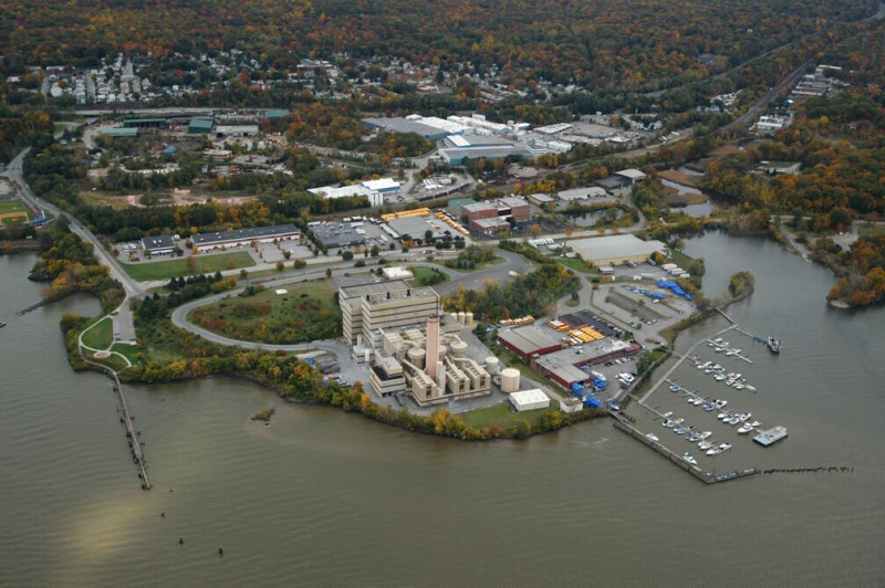
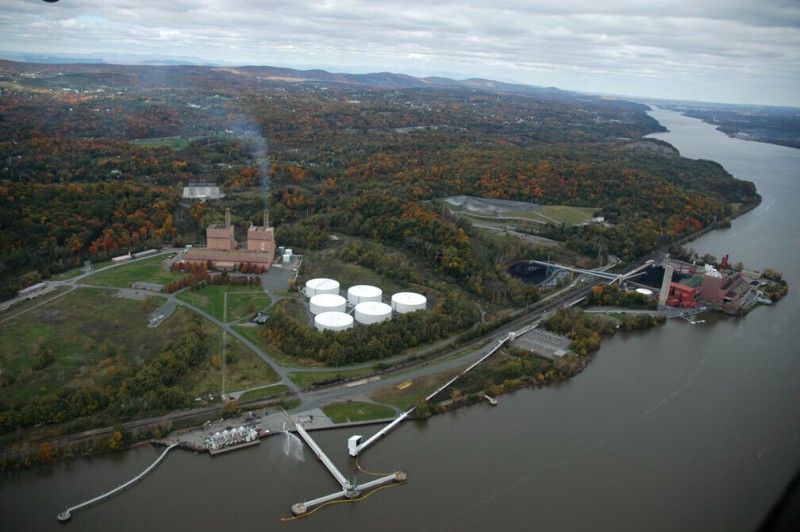
Charles Point is an industrial area on the shore south of Peekskill that used to be the home of America’s largest yeast plant (owned by Fleishmann’s). It is now dominated by a waste-to-energy plant built in 1984. The facility operates an incinerator that burns trash and creates electricity and belongs to the Wheelabrator division of the waste-handling giant Waste Management Incorporated. It burns 2,250 tons of trash per day, including some of New York City’s trash, generating as much as 60 megawatts of power, enough for more than 50,000 homes; the plant, which also burns natural gas, reduces trash volume by 90 percent. The ash is then disposed of in a landfill. This is one of sixteen such plants operated by Wheelabrator across the country. Adjacent to the plant is the headquarters of the National Maritime Historical Society, an organization that preserves historic ships and publishes Sea History magazine.
Camp Smith is a military site that covers two miles of the eastern shore of the river and extends nearly two miles inland. It is designated a National Guard site and is used primarily as a small arms training site for the military as well as for the FBI, DEA, and other government entities. Camp Smith is also an important first responder training site and houses emergency equipment ready to be deployed anywhere in the nation in twelve hours. The grounds are also used for other simulations and high-tech training. Most of the buildings are located on a 300-acre plateau, the rest of the 2,000-acre property being very mountainous.
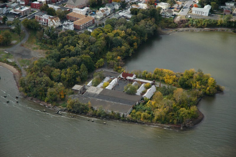
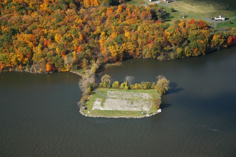
Several large buildings and a network of roads remain on Iona Island, left over from the period between 1900 and the 1960s, when the island was a navy ammunition depot, connected by a causeway to the western shore of the Hudson. During this time the island was also a major rubber repository for the military. Round Hill, at the south end of the island, was quarried into a half circle, and the resultant cliff was used as a shield separating the main base from particularly volatile weapons, stored in earth-covered igloos. Now part of Palisades Interstate Park, Iona Island is operated as a bald eagle habitat from which human access is restricted.
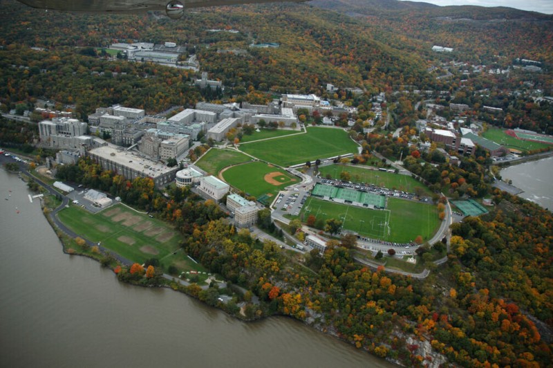
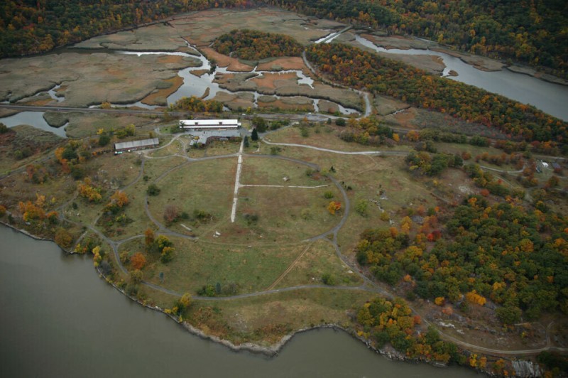
West Point was built at what George Washington once declared was the “most important strategic position in America.” First occupied by the military in 1778, it is the nation’s oldest continuously operating military post. It is also the location of the U.S. Army’s most prestigious school, mandated by Thomas Jefferson in 1802. The early focus of the U.S. Military Academy was on civil engineering, following the principles established by Napoleon and the École Polytechnique in Paris. By the time the Civil War ended, the civil engineering conducted by the military had transferred to the Army Corps of Engineers, and West Point started providing a broader curriculum. Beyond the densely developed, neo-Gothic main campus, facilities on the 16,000-acre reservation include a ski slope and an artillery range and one of the five sites for the U.S. Mint (West Point is part of the nation’s gold and silver bullion repository). Across from West Point is Constitution Island, which is used today exclusively by the military as a recreational area. This is one of the narrowest points on the lower Hudson; in 1778, a large chain was strung across the Hudson here to prevent the British from traveling upstream. This is also the deepest point on the river, 216 feet, at a place called World’s End.
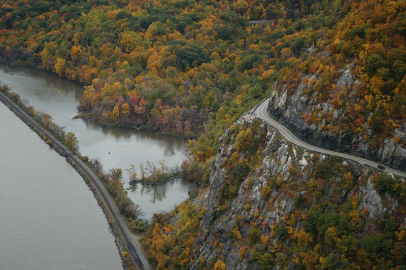
Storm King Mountain rises, dramatically and scenically, out of the western shore of the Hudson. The West Shore Railroad, which carries freight, is at the base. The old Storm King Highway runs along a cut on a ledge near the 200-foot level of the 1,340-foot mountain, and a turnout and overlook on the highway looks across the river to Breakneck Point. Con Edison proposed building the world’s largest pumped storage power plant here, in 1962, starting an eighteen-year-long battle between the company and local citizens opposed to the project. This controversy led to the establishment of legal precedent and national laws that help to put the preservation of the natural environment before the interests of business. Efforts to preserve the scenery of the Hudson continue, often led by Scenic Hudson, the group that was created to organize opposition to the Storm King plant.
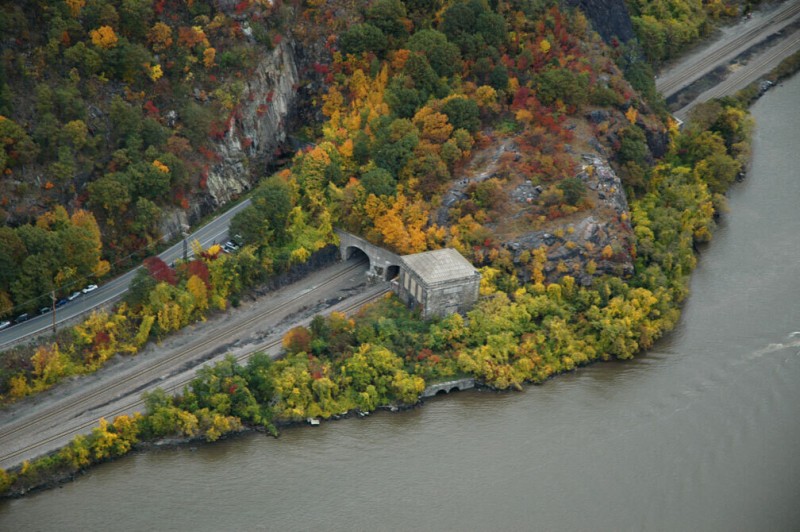
Breakneck Point, at the intersection of Dutchess, Putnam, and Orange counties, is directly across from Storm King Mountain in one of the more abrupt and rocky parts of the Hudson’s shoreline. The cliffs have been worked by quarries, and it is one of the rare spots where the shoreline road and railway pass through a tunnel. It is at this point as well that the Catskill Aqueduct crosses under the river. The aqueduct was built between 1907 and 1915 to connect the upstate Ashokan Reservoir to the Kensico Reservoir, near New York City. The aqueduct is 92 miles long, and most of it is just below the surface of the land, made by the cut-and-cover method. As it passes under the river, however, it is a 17-foot-diameter tunnel bored into rock 1,100 feet below the river. The aqueduct was the second of the three major water supply systems built to deliver water to New York City. Water flows through the pipe at around 4 miles per hour, delivering as much as 650 million gallons per day, 40 percent of the city’s water supply. A square building on the shore is a tunnel drainage shaft structure, which has a cast-steel dome inside it, atop an 1,100-foot vertical shaft that connects to the tunnel.
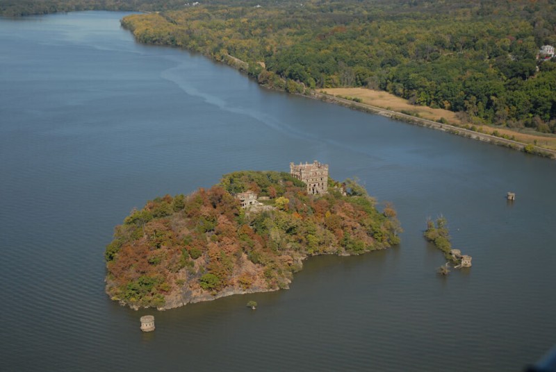
Pollepel Island, better known as Bannerman Island, is a fairyland castle ruin in the middle of the Hudson. It was built as a warehouse and weekend retreat by Frank Bannerman, a military surplus salesman. A Scotsman who had immigrated to America with his family as a child, Bannerman took over his father’s business of buying military surplus, developing the company into one of the largest in the nation (Bannerman is known as the father of the army-navy store). After the Spanish-American War he acquired at auction nearly all of the matériel that the Americans had captured from the enemy, including weapons and explosives. In 1900, he purchased Pollopel Island and began to build this arsenal/warehouse according to his own design. Largely completed by 1910, the arsenal was protected by well-armed guards. Bannerman died in 1918 but his catalog-based surplus business continued—out of a warehouse on Long Island—until the 1970s. The island was sold to New York State in 1967, and much of its contents were given to the Smithsonian Institution. In 1969 a fire burned most of the buildings, and the castle remains off-limits to this day. The Bannerman Castle Trust has been established to preserve the structures, with the intent of one day opening the island to the public.
Newburgh’s waterfront is a mix of recent hopeful upscale redevelopment and industrial maritime remains. At the foot of Washington Street, next to a public boat launch and the parking lot for the Beacon-bound ferry, is an overgrown fenced lot with crumbing buildings known as the Consolidated Iron and Metal Superfund site. Built on a former shipyard site, this scrap-metal yard, which included a smelter used for melting down automotive scrap, operated from the mid-1950s to 1999, when it was shut down by the state as an environmental hazard. Oil, PCBs, lead, and other industrial contaminants have been found in high concentrations in the soil at the site, leaking into the Hudson. A plan to remove much of the soil and debris from the site is being developed.
Over the years the Beacon Landing brownfield site has been a train ferry site and a fuel storage depot. In 1996 the 23-acre property was purchased by Scenic Hudson, a powerful interest group concerned with preservation of the ecological and aesthetic qualities of the Hudson and its shoreline. The organization was prompted to purchase the land in order to block a proposal to build four hundred units of housing on the site. Soon afterward the New York City–based Dia Art Foundation announced plans to convert a 210,000-square-foot box factory nearby into a major museum of contemporary art. What has evolved is known as the Long Dock project, which is transforming the site into an environmentally sensitive mixed-use redevelopment area, with links to the Dia Museum, adjacent parklands, and the shorefront. Designed by Scenic Hudson and the Foss Group (developers selected by Scenic Hudson), the project includes an eco-friendly hotel, a performance space, interpretive areas, and restaurants. The artist George Trakas is turning a portion of the landing into a piece of environmental art commissioned by Dia:Beacon.
The Delaware Aqueduct passes beneath the Hudson River at this point, 600 feet below the surface, invisible except for a gatehouse and other control structures on the eastern shore. The aqueduct is an 85-mile-long continuous tunnel (by some accounts the longest in the world), 15 to 18 feet in diameter, that connects the Rondout Reservoir in Sullivan County to the Hillview Reservoir in Yonkers. Completed in 1965, after the Croton and the Catskill systems were built, the Delaware system is the most recent and far-reaching of the three major water supply systems for New York City. From the end of the Delaware Aqueduct at Rondout, three additional tunnels extend to three more distant reservoirs. The farthest is Cannonsville, near Deposit, New York, 135 pipeline miles from New York City and deep within the Delaware River watershed, which except for this portion that flows directly to New York City drains into Delaware Bay.
The two power plants at Danskammer Point are both operated by Dynegy, a medium-sized utility that operates more than a dozen plants, mostly in the Midwest. The Roseton Plant, on the hill, uses natural gas and oil to generate 1,200 megawatts of electricity. North of Roseton, on the shore, is the Danskammer Plant, a coal-fired plant that is supplemented by gas and oil, which generates 500 megawatts.
Two adjacent hills near Hampton Point were removed over a number of decades by the New York Trap Rock Company and later by Lone Star Industries. The area is now owned by Tilcon, which acquired Lone Star. At Peck’s Dock, the barge-loading conveyor that spans the railroad remains although the site has not been quarried for more than ten years. This site was a dolomite (magnesium limestone) quarry. Dolomite is used in cement and ornamental stone.
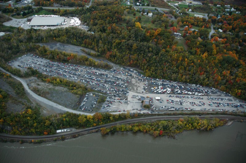
A former sand pit at Peggs Point is now a storage lot for wrecked cars. Copart, Inc., is one of the nation’s leading auctioneers selling for salvage totaled cars and cars recovered from theft by insurance companies. Copart has more than 120 facilities in North America. A large shed-type structure above the Copart site houses Chelsea Modular Homes, a factory that makes full-size residential homes that can be shipped in parts to be assembled on-site.
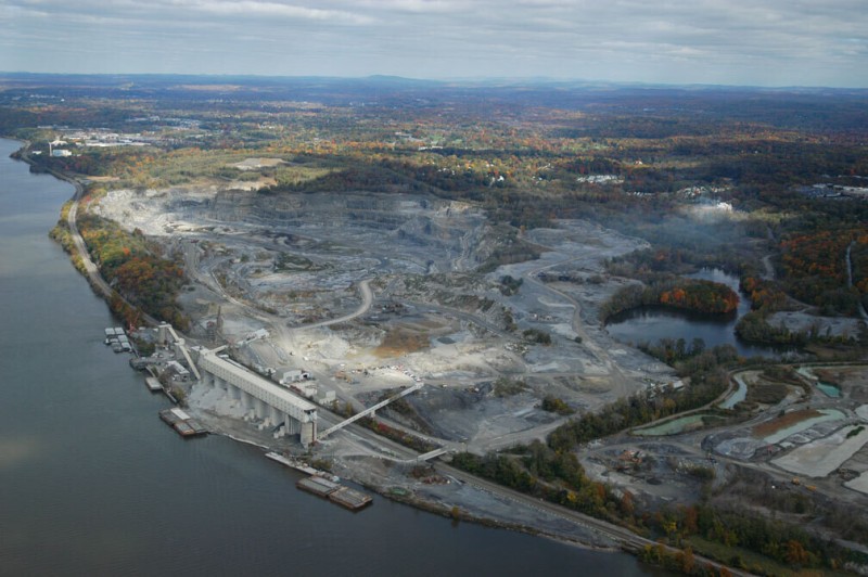
The Clinton Point Quarry is the largest excavation site on the shores of the Hudson. It was originally the estate of the first governor of New York State, George Clinton, who later became vice president of the United States during Thomas Jefferson’s second term. Started in 1880, the quarry was operated by New York Trap Rock for many years. It was acquired in 1965 by Lone Star Industries, and in 1997 it became part of Tilcon’s operations on the Hudson. Amtrak’s passenger railway passes by on the narrow strip of land between the quarry and the shore.
Milton has been a ferry site and a Quaker colony. The dock area used to be an important shipping center for the region’s orchards, berry farms, and vineyards. The Hudson Valley is a major agricultural area, producing fruits, vegetables, and dairy products. The red building on the shoreline was a warehouse operated by Agway. It was then used as a winery before being abandoned. Several oil tanks formerly on the hill above the terminal have been removed.
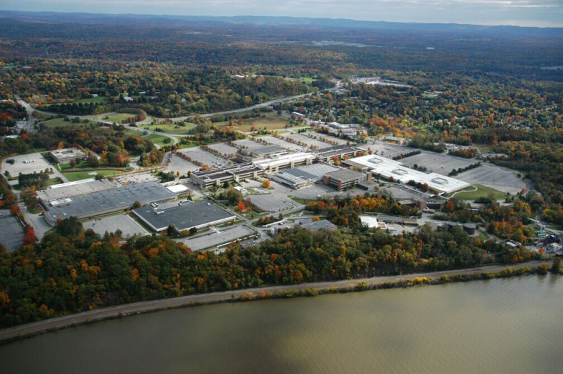
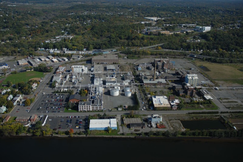
The IBM manufacturing plant in Poughkeepsie is one of the company’s largest and most historically important manufacturing sites. It was begun when IBM bought an old canning factory on the riverfront in 1941. The first part of the sprawling main plant was built in 1948, with wings added in 1952. With several more additions over the years, the plant now has more than fifty buildings on 423 acres. The plant is one of the primary sites producing IBM mainframe computers. Despite major layoffs in the 1990s, IBM is still the mid-Hudson’s largest private employer, with more than 10,000 people working in Poughkeepsie and in nearby Fishkill. In 1964 IBM moved its headquarters from Manhattan to a new corporate campus in the suburbs of Armonk, New York, 10 miles east of the Hudson River and a safe distance from New York City. IBM employs more than 300,000 people worldwide.
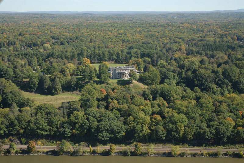
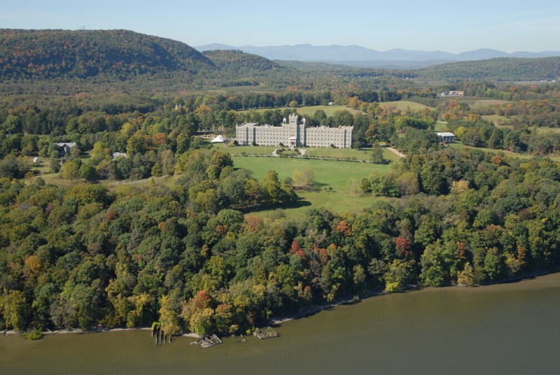
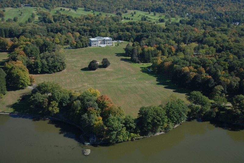
The east shore of the Hudson is famous for its mansions of writers and painters and the opulent estates built by the captains and barons of American politics and industry, from the Roosevelts to the Rockefellers. The Vanderbilt mansion at Hyde Park, near the Roosevelt estate, is one of the most dramatic of these preserved mansions. Frederick Vanderbilt, the grandson of the legendary Cornelius Vanderbilt, bought the 600-acre property in 1885. He had the existing mansion torn down and a new one built by McKim, Mead, and White. Frederick and his wife, Louise, visited the house only a few weeks of the year, generally in the fall and spring, since they summered at their house in Newport and wintered in their mansion on 5th Avenue. A staff of sixty managed the estate year-round. Frederick’s niece inherited the property after he died in 1938, and she donated the house and 211 acres of the grounds to the federal government, which is now charged with its upkeep.
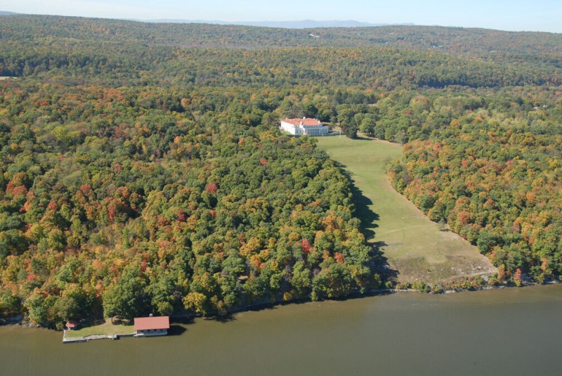
One of the grandest Gilded Age mansions on the Hudson is the rarely visited Payne estate in Esopus. This 486-acre estate was established in 1909 by Oliver Hazard Payne, an industrialist involved in tobacco, steel, and oil (and a former classmate of John D. Rockefeller, who later bought out Payne’s Cleveland oil business). The main house was designed by Carrère and Hastings, architects of the New York Public Library and the Frick mansion. The estate also included the “English Village,” a cluster of rustic-style buildings comprising farm buildings, workshops, and housing for sixty groundskeepers, cooks, and servants. Payne’s large yacht, the 300-foot-long steamer Aphrodite, was often docked on the river, visible down the lawn from the house. After his death in 1917 the property, one of several he owned, was passed on to his nephew, who didn’t use it much. In 1933 he donated it to the Protestant Episcopal Mission Society, which used part of it as a convalescent home. Ten years later it was acquired by the Marists, a Catholic order, to be used as a seminary. The Marists, who also operate Marist College across the river in Poughkeepsie, still own it.
There are several active monasteries, seminaries, and religious retreat centers along the shores of the Hudson, but none is as large and dramatic as Mount St. Alphonsus, located on the west side of the river in Esopus. The 450-foot-long building was completed in 1907 and is still owned by its builders, a Catholic missionary congregation known as Redemptorists. It was built originally as a seminary to house and train theological students studying to become ministers, many of whom went on to serve spreading the gospel in poor communities and developing nations. The seminarians also worked a farm on the seminary grounds, providing much of their own food as well as their sacramental wine. With a decline in enrollment, the seminary closed in 1985, and the facility is operated by the Redemptorists as a retreat center, available to religious groups for a fee.
This mansion north of Hyde Park was built in 1895 by architects McKim, Mead, and White for Ogden Mills and his wife, Ruth Livingston Mills. Mills was the son of the “richest man in California,” Darius Ogden Mills, a New Yorker who capitalized on the Gold Rush and the subsequent development of San Francisco and founded the Bank of California, among other things. His son, Ogden, married Ruth Livingston, a member of the most prominent family along the Hudson River. The Livingston empire arose in the seventeenth century, when Scotsman Robert Livingston secured a royal patent on 160,000 acres of land along the eastern shore of the Hudson. His family would eventually own nearly a million acres in the area, and subsequent generations of Livingstons, and their often affluent spouses, would build dozens of mansions. Most of those that remain, like Staatsburgh, are now maintained by public agencies and nonprofits. Unlike the Vanderbilt estate at Hyde Park, which was donated to the federal government and so has access to deeper pockets for preservation, Mills Mansion was donated, in 1938, to the state of New York, and a full restoration has been slow in coming. This gives the mansion an interesting coarseness; its dulled exterior, for example, is the result of a 1950s coating of gunite.
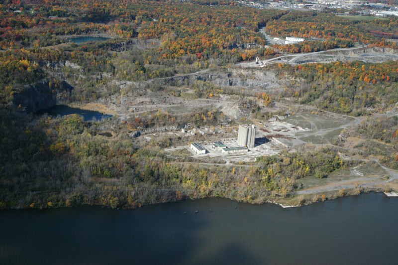
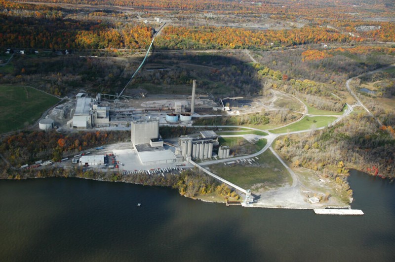
The shoreline north of Kingston was a major cement production area, particularly after 1957, when the Hudson Cement Company built a large plant with a 300-foot-tall storage silo next to the quarries, which still stands today. The operation was bought by Tilcon and continued until the 1980s, when Tilcon closed the site. The proposed redevelopment of the former cement site remains a contentious issue for the region. Kingston Landing, LLC, of Yonkers has proposed building a complex of more than two thousand housing units in and around the site, as well as commercial space and a beach. Nearby, at the old Hutton Brickyard site, the best preserved of the old brickyards along the Hudson, a 350-unit housing and condominium complex called Sailors Cove has been proposed. Many feel that this level of development is inappropriate for the region and would place undue stress on local roads and infrastructure.
Edgewater is an unusual Hudson mansion because it was built on the water’s edge, not on a bluff overlooking the river, like most of the others. The original building dates from 1829 and was built for Margaret Livingston and her husband, Lowndes Brown. In 1851 the railroad built its Hudson River line from Manhattan to Albany along the eastern side of the river, dramatically altering the shore. The line divided her property and the house became isolated on the river side, with the railroad tracks running immediately behind it. Livingston was indignant, sold the house, and moved to Europe. The writer and socialite Gore Vidal bought the house in 1946 and did much entertaining and writing there. He sold it to its current owner, investment banker Richard Jenrette, in 1969 (for $125,000). Jenrette now owns five other historic homes in America and is author of a book chronicling the adventure of restoring them. He founded the Classical American Homes Preservation Trust to preserve his homes in perpetuity. For many years Jenrette also served as chairman for Historic Hudson Valley, an organization founded by John D. Rockefeller Jr. in 1951 that now operates six historic buildings on the Hudson, including the Rockefeller family mansion Kykuit, in Sleepy Hollow.
Ruins of an estate that included a significant romantic ruin “folly” remain at the southern end of Cruger Island, south of the town of Tivoli. John Church Cruger, a prominent New York lawyer, purchased the property in 1835 and built an estate with a mansion surrounded by exotically planted and landscaped grounds. The constructed ruin he built on the property included carved stones brought from Mayan ruins in Mexico and Central America by the nineteenth-century expeditionary archaeologist and author John Lloyd Stephens. Cruger’s inspiration for the ruin is said to have been the Hudson River School artist Thomas Cole’s 1834 painting Moonlight. When the property was sold in 1919 the American Museum of Natural History in New York City bought the Mayan stones, some of which are still on display in the museum. The island was later purchased by Robert Boyd Ward, owner of the Ward Baking Company, whose nearby manor house is now used as a dormitory by Bard College, located on the hill above the island. In the 1950s and ’60s the island was owned by an electrical utility company that attempted to build a nuclear power plant on the site. When this proposal was abandoned the land was sold to the state, and it is now part of the Tivoli Bay Wildlife area and the Hudson River National Estuarine Research Reserve.
Two artificial piers project from the shore on either side of the mouth of Esopus Creek at Saugerties. The northern projection has a lighthouse, one of four remaining nineteenth-century lighthouses with attached lighthouse keepers’ cottages on the Hudson. Though the lighthouses aren’t manned anymore, the cottages are often maintained for tourism and historical purposes. This one has a B&B operated by the Saugerties Lighthouse Conservancy. The peninsula projecting far into the channel south of the Esopus is Long Pier, a former steamboat landing for the town. By the 1950s it was abandoned and in ruins, and it was purchased from the ferry company by a mechanic and sailor from Long Island seeking solitude and a place to park his 40-foot trawler. He repaired the building and lived there until he died a few years ago. The property, which includes the long roadway connecting it to the shore, is now owned by his niece and nephew, who use it on weekends.
Wanton Island, once a natural island, is now flattened and covered with concrete, remnants of former industrial use. It is located at the intersection of the Greene, Ulster, and Columbia county lines, which meet in the middle of the Hudson River. Wanton Island was said to be the site of an Indian battle where the Iroquois established their power over the Mohicans.
Glens Falls Lehigh Cement is one of three adjacent cement plants on the shore across from Germantown. Though this was once the largest cluster of cement-manufacturing activity on the river, each plant now operates at different levels. The kilns at the Glens Falls Lehigh plant were shut off in 1994, and the plant is now used as a shipping terminal and as storage for finishing materials that are brought down the river from its operating plant in Glens Falls. The conveyors that connected the plant to quarries in the hills behind it are no longer active. Like many cement companies, Glens Falls Lehigh is a company formed by agglomerations. Lehigh started more than a hundred years ago in Pennsylvania. Through acquisitions it expanded into the Midwest and the South. In 1977 it was acquired by Heidelberg Cement of Germany, still its present owner. Lehigh entered a partnership with Glens Falls Cement to operate this site in 1999. Glens Falls is owned by Dyckerhoff AG, another German conglomerate.
Next to Glens Falls Lehigh Cement is Silver Point, where the ruins of the Malden brick plant lie in collapse in the overgrowth. To the north, a causeway and artificial peninsula, connected to an island, once was the dock for the cement plant at Alsen. This plant, built in 1902 by the Alsen American Portland Cement Corporation, based in Hamburg, Germany, was bought by Lehigh in 1925 and closed after Lehigh bought the adjacent plant (to the south) in the early 1980s. This site has devolved into one of the great industrial ruins remaining on the Hudson. Next to Alsen is the still-active St. Lawrence Cement Company’s Catskill plant. The plant may expand its production here in the future, since plans for a massive new plant in Hudson were thwarted by local opposition. St. Lawrence Cement is based in Montreal, Canada, and owned by the Swiss aggregate company Holcim, which is the largest producer of cement in the United States. In 1906 the name of the nearest town, Smith’s Landing, was changed to Cementon, reflecting the industry that dominated the area and employed the people of the town. In 1992 the residents of the town voted to change the name back to Smith’s Landing.
On the shore a few miles south of the city of Hudson are the remains of Burden Dock, the former loading area for a major source of iron ore used in the monumental nineteenth-century Burden Iron Works at Troy. Ore would come to the dock on a dedicated railway connected to the mines, located a few miles away, and then was barged upriver to Troy. The mines, bored into Mount Tom, a small hill behind the dock, employed 550 people in the late 1800s and extracted 1,200 tons of ore a day. The town of Burden, near the mine site, is now mostly gone. The underground mine, however, continues to be used, but not as a mine. In 1936 the depleted mine was purchased by Herman Knaust to expand his mushroom farming operation. In 1951 Knaust founded the Iron Mountain Atomic Storage company and soon banks and other companies began storing records in vaults in his mine, a safe distance from the city. The operation continued to grow, and by the 1970s Standard Oil is said to have had fifty sleeping rooms and a dining hall inside the mine for use by company officials to continue to run the company in the event of a nuclear attack. Today, Iron Mountain is the largest records-storage company in the country and operates many aboveground and underground facilities, including others in the Hudson Valley at Rosendale and Esopus.
Catskill Point is a promontory built into the water as a boat terminal. For many years this was a stop on the Hudson River Day Line, a steamboat company operating between New York City and Albany from the late 1800s to 1948, connecting the urban population with the popular recreational attractions of the Catskills. At Catskill Point, passengers boarded the Catskill Mountain Railroad to head into the mountains to the west. Now, historic buildings on the site have been turned into an exhibit center and local seasonal market, and most of the land on the peninsula is used for propane and gasoline storage as well as a sewage treatment plant for the town of Catskill.
The southern shore of the city of Hudson is an old industrial region in transition. A large pad and shed here belong to St. Lawrence Cement, which owns the remains of a cement operation that included a large plant and quarry east of town. The route of the conveyor that carried cement to the dock from the plant is still visible. Cement production here ceased in the late 1970s, but for nearly a decade St. Lawrence Cement proposed reactivating some of the quarries and building one of the largest cement plants in the nation here, until local opposition terminated that proposal in 2005. The dock area is still used for handling bulk materials, such as road salt. North of the dock are some remnants of shoreline industries, such as a former gas plant site that was recently remediated by Niagara Mohawk and a former slaughterhouse that is now an art space called Basilica Industria.
Several old barges have been left to rot in a cove off the shore of the small town of Athens. The barges are next to the shoreline facilities of Peckham Industries, a road construction materials company. Peckham quarries gravel and it operates several asphalt plants in the Hudson Valley. Athens is one of three terminals owned by the company (others are in the Bronx and in Bridgeport, Connecticut) where asphalt and aggregates are handled and transported by barge. A quarry in the hills behind Athens produces crushed stone.
An occasional redbrick smokestack can be seen poking out from the trees along the Hudson. In most cases they are remnants of a brick plant or an ice plant. At Nutten Hook, a natural bulge in the shoreline of the river across from Coxsackie, it marks the ruin of an ice plant powerhouse (and, south of that, the ruins of a brick plant at Little Nutten Hook). This powerhouse sat in the front and middle of a massive wooden icehouse 300 feet long, built by the R. W. Scott Ice Company in 1885. Several sloped elevators ran from the face of the building to the shoreline. During the winter, ice harvesters working on the frozen river would cut blocks and pole them along to the base of the plant through small canals cut into the ice. There, the elevators, powered by the plant, lifted them into the icehouse. The blocks were packed in sawdust and stored until there was demand for them in the city in the summer. Artificial refrigeration ended the natural ice industry in the early 1900s. This icehouse (and several others) was then used for mushroom farming but burned down in 1934. The New York State Department of Environmental Conservation bought the 114-acre property in 1990 and it is now part of the Stockport Flats component of the Hudson River National Estuarine Research Reserve. There are plans to develop a boat ramp and an exhibit hall or museum at the site.
The southern end of a peninsula 10 miles south of Albany is a dumping ground for material dredged from the bottom of the Hudson River by the Army Corps of Engineers. Known as Schodack Island, the peninsula is actually a composite of several islands that have been merged into one landmass over more than a century of material dumping. Starting in the 1860s, rock and timber dikes were built on the western edge of the islands, along the main channel, forming a wall to hold back the muddy flats. As the channel was deepened, the dredged material was dumped behind the dikes, filling in the gaps between the islands. It is now a 1,000-acre artificial peninsula operated as a wildlife area by the state parks department.
The lower Hudson River was the largest brick production center in the nation in the late nineteenth century. Dozens of brick plants lined the shores, especially around Haverstraw. Though farther upriver than most, the Powell and Minnock Brick plant in Coeymans was the last to close, because of a timely investment in new technology in the 1960s that modified the plant to work with high-calcium shale discovered at a quarry in Coeymans Hollow, six miles inland. It also had the substantial backing of the defense contractor General Dynamics, which owned the plant in 1969 as part of its Materials Services Corporation subsidiary. Powell and Minnock produced bricks that were trucked to the New England market via the nearby New York State Thruway up until the 1990s. Eventually the pressures of larger volume requirement and more efficient production at plants in the southern United States closed this plant too, and it was sold to Albany Gravel in 2002. It is now used as a bulk materials dock and a construction yard.
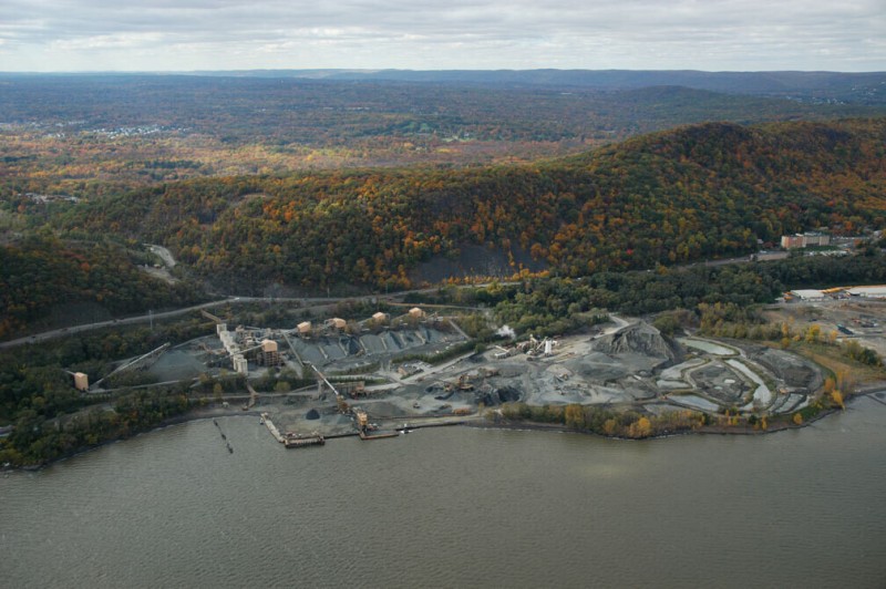
Ravena Dock is a cement-loading dock near Coeymans, connected by a covered conveyor belt to a cement plant more than a mile away. The conveyor, which passes under the New York State Thruway, is part of a more extensive conveyor system that connects the plant to quarry sites farther inland. The operation is owned by Lafarge, often cited as the largest construction materials company in the world. Headquartered in Paris, Lafarge has more than eighty thousand employees in seventy-six countries, including fifteen thousand employees in North America. This is one of twenty-four cement production sites operated by the company in North America. It was acquired when the company bought Blue Circle Cement in 2001.
Although it is a few miles from the river, General Electric’s main plastic manufacturing plant in the United States is connected to the river by an outfall pipe located beneath a small blockhouse on the shore. The pipe discharges treated wastewater from its plant operations and cooling water from its power plant. The plant, at Selkirk, makes the company’s Noryl brand of polyphenylene oxide, a versatile plastic resin widely used in consumer products such as cell phones, televisions, and automobiles. Among its properties is an ability to hold colors and to be finished to look like metal. Next to the outfall is the Alfred H. Smith Memorial Bridge, a railroad bridge that connects to a large rail yard next to the GE plant in Selkirk, which is a major automobile logistics yard operated by CSX. The road bridge that crosses the river here is the mile-long Castleton-on-Hudson Bridge, holding the Berkshire Spur of the New York State Thruway.
The Bethlehem Energy Center is a new power plant built next to an old one a few miles south of Albany. When it went online in 2005, the old Albany Steam Generating Station next to it was shut down. The new plant makes twice as much power (750 megawatts) and takes advantage of new technologies that make it cleaner and more efficient. The old plant, built in 1952, used oil, supplemented by natural gas, to boil water, which generated steam pressure to turn the turbines. The new plant burns natural gas (supplemented by oil), which turns the turbines directly. The new plant also has a closed loop water system, so it is not constantly drawing all of its cooling water from the Hudson. The plant is owned by PSEG, which bought the old plant from Niagara Mohawk in 2000. PSEG, a New Jersey–based electrical utility with $10 billion in annual revenues, recently became part of Exelon, a Chicago-based utility with $15 billion in annual revenues. Together they have dozens of power plants and serve more than seven million customers.
Pharmaceuticals and chemicals have been manufactured at this plant for more than a hundred years. Most of the facility is now operated by AMRI Rensselaer, Inc., a custom drug manufacturing company that makes ingredients for clinical trials and commercial products for its parent company, Albany Molecular Research Incorporated (AMRI). AMRI, headquartered in Albany, has research and development centers in Albany, Rensselaer, and Syracuse, as well as in Singapore, Hungary, and India. Historically the plant has made drugs for companies including Sterling Drug, Kodak, and Nycomed, and for more than fifty years the plant has made DEA-controlled substances, including amphetamines, barbiturates, anabolic steroids, and synthetic narcotics.
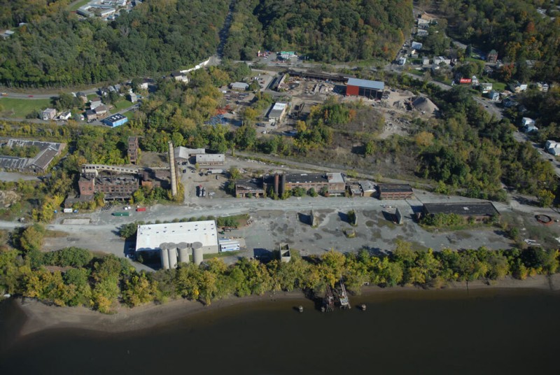
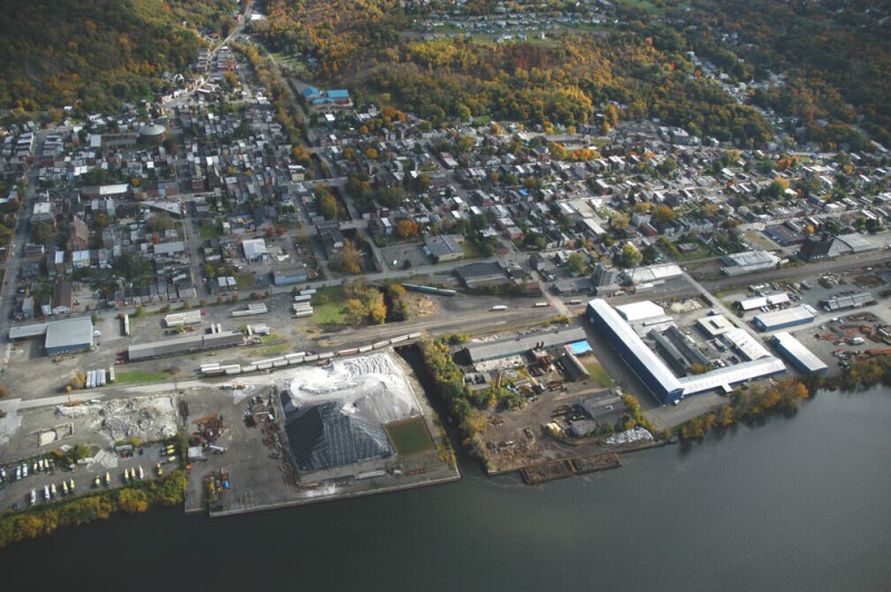
The largest remnants of Troy’s heavy industries lie at the southern end of town. This was the location of the Albany Iron Works and the Burden Iron Works. The Albany Iron Works site, just north of the Troy-Menands Bridge, is famous for producing the plates for the Monitor, an armored Civil War ship that fought against the Merrimack in the first battle between ironclad ships and later sank in a storm. The Bessemer Steel Works, on the east side of the site, was the first steel plant in America. A rolling mill on the site was still in use into the 1970s by the Portec Company. Portec leased part of the site to the Troy Transfer Company, which has ground up much of the buildings in the process of operating one of the city’s main waste transfer stations. King Fuels operated a fuel storage business on this site, and its large gas storage building with a painted winking eye was long a major landmark. The tank was torn down in 2004, when Niagara Mohawk (now National Grid) cleaned up its old gas plant on the site. To the north the Burden Iron Works extended up the creek to a famously large waterwheel, 60 feet in diameter (said to have inspired the creation of the Ferris wheel by RPI alumnus George Ferris). The Burden wheel disintegrated in the late nineteenth century, and the plant, operated by Republic Steel until the 1960s, is nearly entirely gone.
The Poestenkill is one of two creeks that powered the industries of nineteenth-century Troy, and it flows as a straightened canal through the south part of the city to the remains of one of the region’s principal industrial sites on the Hudson, the Rensselaer Iron Company. This plant has changed ownership, name, and form over the years, starting in 1846, eventually becoming Ludlow Valve, the largest valve and hydrant producer in the country. The site is still a working waterfront with scrap yards and bulk storage operations operated by the Troy Slag Company, Callahan Industries, and others (a large mound on the site is rock-salt storage). Few of the old buildings remain, though the city hopes once the contamination issues are addressed to renovate one on the south side of the Poestenkill as part of an environmental research center and to open a recreational and industrial heritage park on the site.
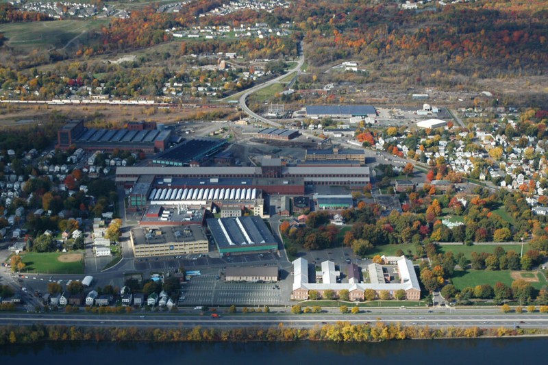
Watervliet Arsenal, opened in 1813 and still in very active operation, is the oldest manufacturing arsenal in the nation. This 150-acre industrial center employs around a thousand people and is the nation’s only large-bore cannon manufacturer. Its products include the barrel of the army’s main battle tank, the M1 Abrams. Watervliet Arsenal was founded at this location to support military efforts in the War of 1812. It grew and industrialized with the connection of the region to the canal systems to the north and west and the iron and manufacturing industries across the river in Troy.
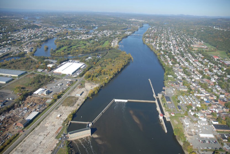
The first obstruction on the Hudson River north of Manhattan is the Federal Dam. This marks the end of the river as a tidal estuary, 150 miles from Battery Park. A lock on the east side of the dam allows boats to continue northward through a series of locks into the Great Lakes, via the Mohawk River and Erie Canal, and to the St. Lawrence River in Canada, via the Champlain Canal. On the west side of the dam is a power plant with original equipment built there by Thomas Edison. A Ford Motor Company plant on the shore was torn down a few years ago. Scrap yards operate in the area now.